
Comments Off |  Share Article
Share Article 


Dayna Vettese ***Update below: video & GIF added***
Hello from Lubbock, Texas!
Well, today was a nice surprise! We started the day in Amarillo, TX and made our way south toward Lubbock, TX. It was a very marginal storm day so we didn’t have high hopes of getting much of anything but maybe some pretty structure. The Storm Prediction Center outlined a MARGINAL risk for the area with a 2% tornado risk for our target area.
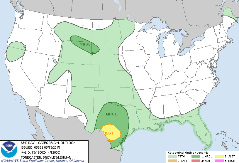 Storm Prediction Center's risk for May 13 issued on the morning of May 13.
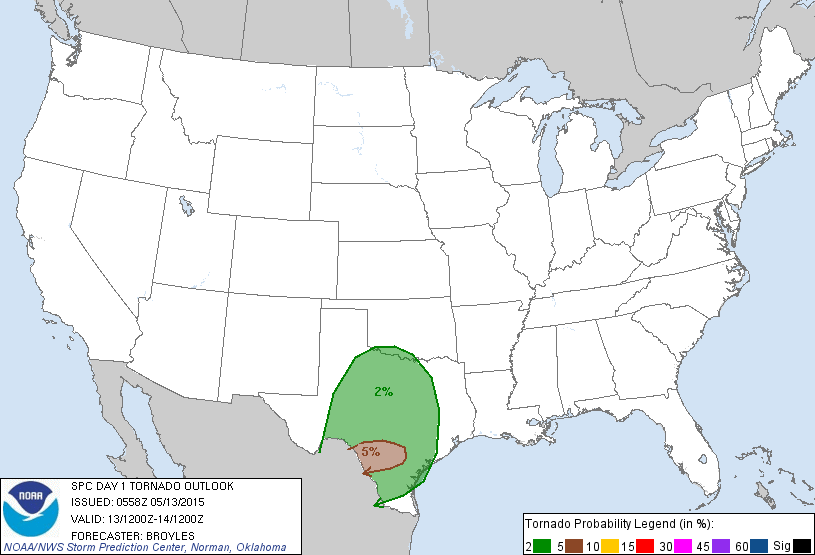 Storm Prediction Center's tornado risk for May 13 issued on the morning of May 13.
A weak dry line was forecast to move into the area we were targeting around and east of Lubbock and this was where we though the storms would fire.
After grabbing a quick lunch, we decided to head out of town to be able to get a clearer view of the sky and horizon. Some cumulus started to go up and die off quickly and we spent a long time on the side of a lonely highway just south of Lubbock. Finally a few storms east of us started to really build up and show up on radar. We decided to head east.
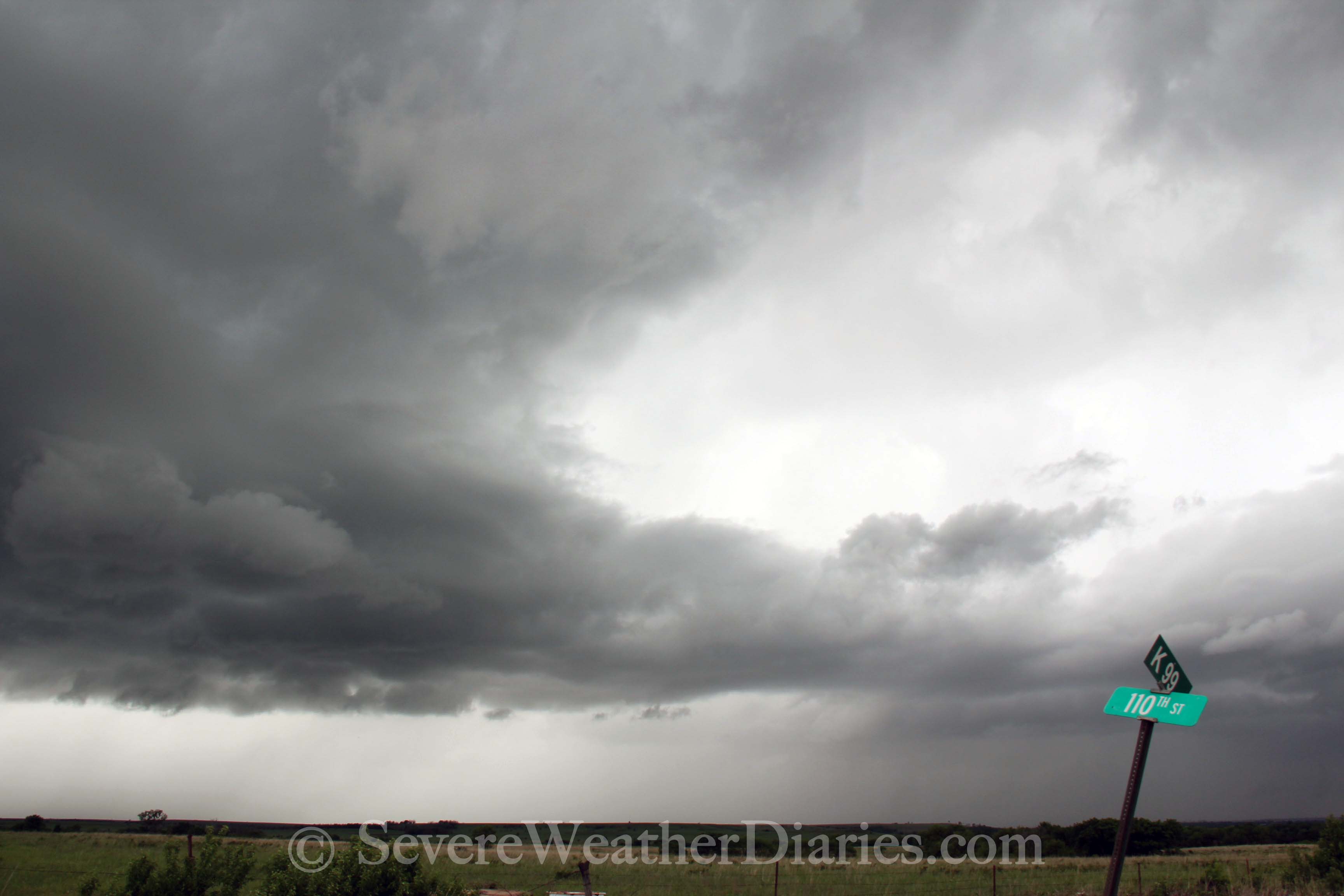
Since the storms were to out east, we had to punch through them to get to the other side to get a nice clear view. After driving through their heavy rain, we emerged on the east side of the storms in and around the Guthrie, TX area. We watched the storms and they showed some promise showing weak signs of rotation. We headed up the road a bit more to get a clearer view, about two miles east of Guthrie and turned to watch. This was our position.
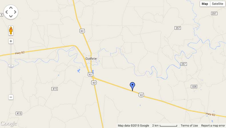 Our position from which we viewed the tornadoes.
At about 5:50pm CT, sure enough, a wall cloud formed and a small funnel appeared. It reached about 70% to the ground. We can’t confirm if it was on the ground but it sure looked like it was. At the same time as this funnel started to lift a few minutes later, another strongly rotating wall cloud formed just north of it and dropped a cone shaped tornado! From our vantage point it appeared to be out of the town. We attempted to submit a tornado report but our connection kept failing. I was able to get a tweet through and we’re told the proper authorities saw the tweet. This tornado was likely on the ground for 5-10 minutes. All photos can be found here. I haven't had a chance to edit video just yet.
UPDATED: Video edited shot by our chase partner this season, Matt Grinter. Radar GIF also added below.
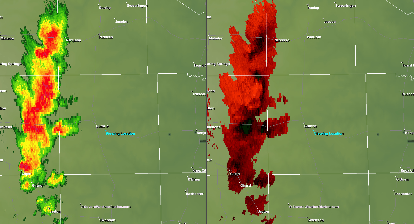 Radar GIF loop of reflectivity and base velocity on May 13, 2015 from 5:06pm - 6:32pm CT.
Once it lifted we kept up with the storm. It kept producing wall clouds but wasn’t able to organize itself enough to put down another tornado. We did come across a small smoldering pile of brush in a field due to a lightning strike. However, because of all the rain Texas has been receiving, it did not spread and was quickly going out.
This was our first tornado of the season and our first tornado since the El Reno tornado on May 31, 2013. It was Matt’s first tornado ever.
Tomorrow looks like another chase day in this area then we head north, way north, to chase the weekend set up.
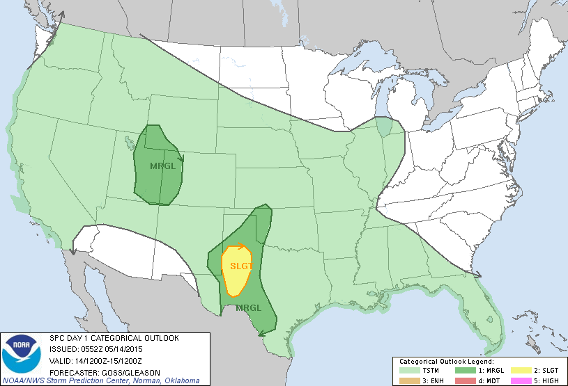 Storm Prediction Center's risk for tomorrow (May 14).
Share Article Dayna Vettese Hello from Amarillo, Texas!
Today was another non-chase day. We headed west and south out of Dodge City, KS to make our way to Amarillo, TX. We are making out way west to get into position for some possible "upslope" play over the next couple of days. These are very marginal but worth a shot. The real deal begins Friday with a few days of possible intense chase days. To read more about that set up, visit Brad's blog here.
The truck is getting some service done (oil change and stone chip in the windshield fixed). So far we've put in about 4600 km (2860 miles) and eight states!
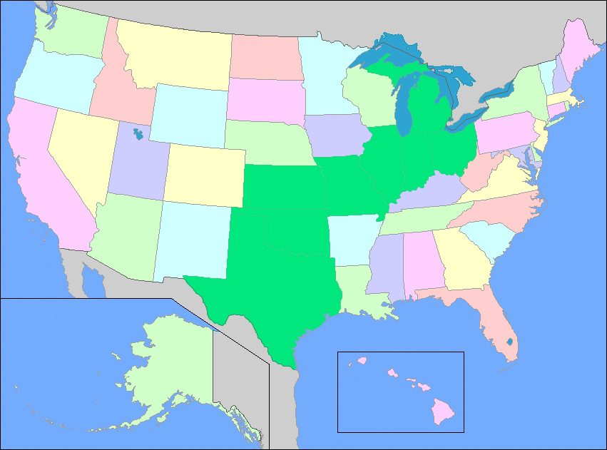 States coloured in green are the states we have driven through totalling eight states in six days.
Tonight we'll likely head to The Big Texan for some good Texas eats. We'll reasses the forecast tonight and decide out plan for tomorrow.
Share Article Dayna Vettese Hello from Dodge City, Kansas!
Today was a non-chase day. We had an awesome dinner last night in Wichita, KS at a Texas Roadhouse and a few "beverages" with Chris Kridler and the Storm Hunters team Mark Robinson, Jaclyn Whittal, Michel Millaire. We all caught up on some much needed sleep and slept in this morning. After a late breakfast, Matt, Brad and I decided to slowly meander our way west. The next possible chase set ups could be some very marginal risk days in either the TX panhandle or maybe SE CO. Instead of trying to make a long haul drive on of these days, we thought it would be better to just make a few hours every day.
We travelled west out of Wichita, KS and stopped in Greensburg, KS. Brad and I have visited the place several times since we started storm chasing in 2010 but Matt had never been there. We can't believe how much the town has grown. For those of you unaware, Greensburg, KS was hit by a devastating EF5 tornado (the strongest a tornado can get on the scale of 0-5) on May 4, 2007.
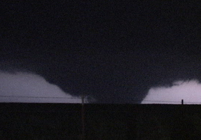 Photo Courtesy: Melanie Metz - The Greensburg, KS EF5 tornado on the night of May 4, 2007.
About 95% of the town was destroyed. The tornado hit the town just after 9:30pm CT causing several fatalities. It's quite amazing how there is still so much evidence of the massive tornado: many trees never recovered, there are many empty and exposed foundations, many walkways that lead to nothing where a house once stood...
 Radar loop of the storm that produced the Greensburg, KS EF5 tornado on May 7, 2007.
After leaving Greensburg, KS, we headed to Dodge City, KS and are spending the night here. We'll do some more forecasting for the coming days and catch up on some video and photo editing... Oh and sleep!
Share Article Dayna Vettese Hello from Wichita, Kansas!
We started the day off in Pratt, KS where it was down right chilly! It should not be chilly while storm chasing… In the morning it did look as though the best chance for storms and tornadoes today would be on the South Dakota – Nebraska – Iowa border. This was too long a drive to make for us but we decided to try to head north to the Kansas – Nebraska border to see what we could get! We headed north out of town and made it all the way to Concordia, KS but were assessing the weather situation along the way and paused in Concordia. After looking over data, we realized the northern storms weren’t performing like that day had first indicated in the morning. We did notice, however, that back in southeast KS like some instability and a good environment were setting up.
 Southeast Kansas near Eureka and Yates Center.
So what did we do? Pulled a U-turn and went back the way we came! We vectored south and east and ended up along the 54 between Eureka and Yates Center, KS. Some storms fired in our area and we followed this one storm for a while. It held a lot of potential but just couldn’t get its act together. Our going theory is that the cold front was just surging too quickly. We kept getting in and out of warm then cold air.
After watching the storms, shooting video, photographing it and hanging out with a local herd of cattle, we decided to call it a day. We headed back to Wichita, KS for the night and had a much-deserved sit down meal! It’s been nothing but gas station food, snacks and fast food for the past several days so it felt nice to eat some real food. New images from the chase today have been added here.
The day didn’t pan out quick as expected though there were several tornado reports from SD, IA, southeast OK and eastern TX. Unfortunately there was quite a bit of damage done in the SD tornado. In the end, we’re glad we didn’t make the long haul to the northern storms because the drive would have been horrendous for little to no pay off.
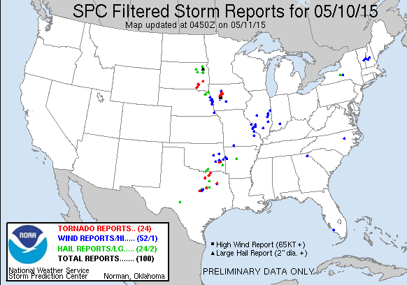 Storm reports from May 10, 2015 via the Storm Prediction Center.
Tomorrow is still up in the air as to what exactly we’ll be doing. Likely it will be more of a down-day or travel-day. We will reassess in the morning. The risk area from the Storm Prediction Center for tomorrow is out of good chase territory (or where we’re willing to chase) so we won’t be venturing east to the SLIGHT risk.
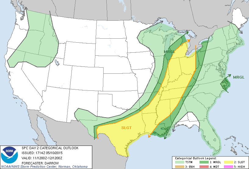 Storm Prediction Center's Day 2 (Monday) thunderstorm risk.
Apologies for not editing any video yet. I honestly don’t have any overly compelling video to post but I do have some pretty cool time lapse video that I would like to get around the editing. By the time we’ve been getting in at night it’s been too late and editing while on the road is… well... nauseating! Will try to get to that soon.
Share Article Dayna Vettese Hello from Pratt, Kansas! It's currently raining and thundering outside...
We began the day in Clinton, OK Our big worry for the day was that there was a lot of morning convection (storms) going through the target area. We woke up to a misty, foggy, cool morning. We made our way toward Woodward, OK where we stopped to reassess the forecast. It was a very foggy drive but when we got to Woodward, the heavens opened up! It was absolutely pouring. We spent some time in a McDonald's mooching off the wifi. After a few hours we decided that the environment would likely re-energize so we headed to Turpin, OK which is due south of Liberal, KS.
We start to see some blips on the radar so we repositioned north in Sublette, KS where we hung out watching the skies for a few hours. The cumulus were really struggling to break through the cap and just did not seem to have enough moisture. Some storms fired off to our south in the Oklahoma panhandle so we headed south to meet them. Having backtracking through Turpin, we continued east toward Forgan and watched a couple of storms do their thing.
Unfortunately they just could not perform today and cap kept winning. We did get some beautiful pictures of the storms and structure at sunset but a tornado was not in our cards today. We did manage to see two shear funnels though! New images have been added to the photo gallery here.
There were many tornado reports and we've seen some crazy images of tornadoes in Colorado and Texas. We're sad to hear that there was likely a fatality in the Texas tornado. Today was a difficult forecast so I'm not down on us for not seeing anything but it sure was a frustrating day!
Tomorrow doesn't look to be anymore straight forward either... We're positioned in Pratt, KS and as of our drive here, anywhere from Omaha, NE to eastern KS to southern TX are all in play for tomorrow. We're hammering out a forecast now.
 Storm Prediction Center's Day 2 (Sunday) risk for severe storms.
Share Article