


May 31 - Chase Day 16 - Dangerous Storm & Dangerous Driving
Wow ... Our worst fears unfolded today and it was what we were worrying about all day: dangerous storms and a lot of people out looking at the storms.
We started the day off in Norman, Oklahoma then headed west to El Reno. We stayed in El Reno for a while waiting for initiation and more and more chasers started pouring into the town. This is when we started getting nervous. Storms initiated just west of El Reno and we eventually positioned ourselves south of El Reno south of the I-40 on the 81. We had a great view of the storm and on its current track would take it just north of us but unfortunately through El Reno.
This is when things started to unfold ...
Brad and Greg were observing the storm but my attention was elsewhere. I was watching the hordes of chasers AND locals (this was NOT all chasers, there were more locals out than chasers, I was there, I saw it) and what I was seeing was brake lights ... Brake lights lit up on our escape route south.
We positioned ourselves where we were because we were out of the path of the tornado and had a great route south to avoid it if it turned right. Well, I was seeing our escape route disappear before my eyes and more and more people started clogging the road. The issue wasn't just the amount of people but people weren't pulled all the way off the road, merging in and out, locals panicking and driving really slow or very erratically.
We then hear from Cloud 9 Tours that there is a tornado on the ground and sure enough we can see it in the rain ... and it's BIG. But it kept disappearing in the rain but based on the HAM radio we knew it was still on the ground. The storm then seemed to be advancing toward us ... It was turning right. That's when Brad, Greg and I decided it was time to leave. Our escape was disappearing and the storm was advancing so we left. We started south as fast as traffic would let us all the while looking back and seeing a mass of dark headed our way. This storm was turning right, it was barrelling toward us, a very hard right. People were panicking (not chasers, this was locals) clogging up roads and slowing down, speeding up, driving on the shoulder, etc. I can't blame people for panicking, and I'm not placing blame, I'm just stating what happened.
We managed to circumnavigate slow moving vehicles and we never did more than 50 mph because the traffic didn't allow for it. We made it south and out of the way of danger. Our friends were behind us and I was sick to my stomach worried. They made it south just in time and to safety.
We can't say the same for locals and chasers who got caught up in the tornado. We also found out that the "mass of darkness" moving toward us was indeed a very large, wedge tornado. I will review pictures and videos to see if I got it but honestly, my goal was getting us to safety, not taking video.
We have heard of many chasers caught up in the tornado. The issue with playing it too close is that storms are unpredictable. There was no way to know the storm was going to turn right that hard so if you leave no room for error, you're going to get hit. But, people are free to do what they wish. If getting as close to a tornado as possible if your goal, I cannot tell you otherwise. That is your choice. You are free to chase storms however you see fit. The only thing that REALLY bothers me is when people block roads and that happened yesterday (May 30) and it happened again today when a tour group (who I won't name) decides to flip a VERY slow U-turn on the highway to head back north to the storm while everyone is trying to flee south. This caused a chain reaction slow down which most likely trapped people back close to the tornado.
Our group played it safe and we always do. The only thing we could have done differently was head south a little earlier because of the traffic. We didn't anticipate it being THAT bad. Other than that we played it well.
I'm sad to hear the death toll has risen. We also know of several friends injured or in vehicle accidents yesterday. I am glad to hear they're all ok though but I don't think our group will ever be chasing anywhere near Oklahoma City ever again. There are too many chasers (I'm not being a hypocrite, I know I am one of them), and there are too many locals, media chasers, etc out to take a look and with that big a population in a metro, you're going to get traffic jams. It's just too dangerous to chase in that area. I would also like to make it clear again that I saw more local vehicles then I did storm chasers so we cannot place all the blame for the traffic jam on chasers. It was panicked locals that caused the jam. I'm not blaming the locals for panicking, I'm just stating the fact.
Anyway ... Our last chase day was a big one, a scary one, and one I would NEVER like to experience ever again. The trip overall was eventful (to put it in polite terms) and I'll do a summary over the next day or so.
Tomorrow we leave for home. Hoping to make it to eastern Indiana or western Ohio. On Sunday we will continue home to the Toronto area. Goodnight everyone!
 Dayna Vettese
May 30 - Chase Day 15 - The Hook & Driving Nightmare
What a day ...
We started off in Pratt, Kansas and blasted south into Oklahoma due to early initiation. We got on storms near Perkins, Oklahoma. Due to the direction in which we were coming we punched in through the west side of the hook. This can be a very dangerous position in certain situations. Today the hail core was well to the north of the hook and we had great visual on the wall cloud. As soon as we got on the storm we saw it ... A massive convergence of storm chasers, police officers and locals ... and it was a disaster.
Some of the worst driving was actually locals stopping in the middle of the road and not pulling completely over.
We saw a brief spin up as we watched the wall cloud. As this was happening a second area of rotation from an approaching storm was rapidly coming up behind us from the west. The circulation on the main storm was north and east of us so our safest option was to continue quickly east.
Easier said than done ...
We start east down the 33 then end up stopped ... Dead stopped. Brad jumped out of the car to see what the issue was because, frankly, we needed to get going fast. If the storm behind us dropped a tornado we would be directly in its path.
Upon inspecting the problem, it turns out the Dominator 2 (D2) was half in the road and half off the road horizontally effectively blocking all eastbound traffic so no one could get through. Not to mention there were gawkers everywhere trying to get a look at it. I don't know if the D2 spun off the road or just pulled off there ... either way it was a dangerous situation. No one could get by and that was the way we needed to go. Since the circulation was rapidly approaching we had no choice but to race the circulation west and then head south.
Because of this traffic jam caused by horrible drivers and fortified chase vehicles, a whole line of cars was in direct danger. We are VERY lucky that second circulation did not drop a tornado. If it did, all of those trapped vehicles would have been in the direct path.
Without getting into a rant about the whole situation I'll just leave it ...
Anyway, because of that jam up we were put WAY out of position for the storm and even missed a tornado (albeit very brief). We abandoned those storms as they weakened and headed south. All the southern storms started dying off so we called it a day.
We're now in Norman, Oklahoma and getting prepared for our last official chase day tomorrow. The SPC has issued a moderate risk for tomorrow. Time to get some sleep. I didn't get a chance to take much video or pictures today because of the dangerous driving situation but what few I do have I will try to get up in the next couple of days.
Also, the wedge tornado we saw near Bennington, Kansas (Ottawa Co.) was rated an EF-4 by the NWS. The damage done to the area was EF-3 but a Doppler on Wheels vehicle measured wind speeds in the tornado that match that of an EF-4. Our first wedge and EF-4 tornado ...
May 29 - Chase Day 14 - Messy Storms in Kansas
Good evening from Pratt, Kansas ...
Today had potential to be a big tornado day. It was given a moderate risk by the SPC as well as a 15% hatched for tornadoes (lowered to 10% throughout the day).
Looking at the SPC reports there were tornadoes reported, most of them in Nebraska, outside of the hatched area. A couple of tornadoes were reported in Kansas, both very brief and no damage (one of them was likely a gustnado, not a tornado). There was one landspout reported in the Texas panhandle. The majority of the tornadoes occurred outside the hatched area.
Today panned out like a very messy LEWP day (line echo wave pattern). We had screaming south winds, good CAPE but there were some issues: there were a lot of outflow boundaries that negatively impacted storms today and also no real focus point for forcing and initiation. Storm went up and quickly formed into a messy line of storms with embedded rotation ... Fairly impossible to chase and see.
From Salina, Kansas in the morning we headed south to Great Bend then toward Liberal, Kansas. We didn't make it all the way to Liberal because storms just weren't initiating in an organized, isolated fashion. We headed north toward Garden City and slightly north of town and watched. Some isolated storms started firing west of town so we headed that way but they too quickly formed into a line.
Calling it a day we headed to Dodge City to eat at Casa Alvarez (an incredible, family owned, hole-in-the-wall looking Mexican joint, really good!) then to Pratt, Kansas to spend the night.
We have a 30% hatched probabilistic for tomorrow's risk ... Shear should be more perpendicular tomorrow which will help keep storms isolated but we may run into the same problem we did today: too many left over outflow boundaries and no real great focus for initiation.
Thursday and Friday will be our last two chase days then we start to head home Saturday. We will likely be following severe weather home ... I can't believe this trip is coming to an end already!
May 28 - Chase Day 13 - Wedge Tornado in Kansas!
Hello from Salina, Kansas!
We saw it ... we finally saw a wedge tornado today near Bennington, Kansas. Before I get to the story I would like to mention that we have had reports of damage from this tornado and while we love seeing tornadoes we're always devastated by the news of damage and injuries. We heard there was damage and saw some ourselves but we have yet to hear of injuries and death. For the most part the tornado seemed to be over field. The tornado could have taken a track directly through town which would have been more devastating.
Ok, onto the day ...
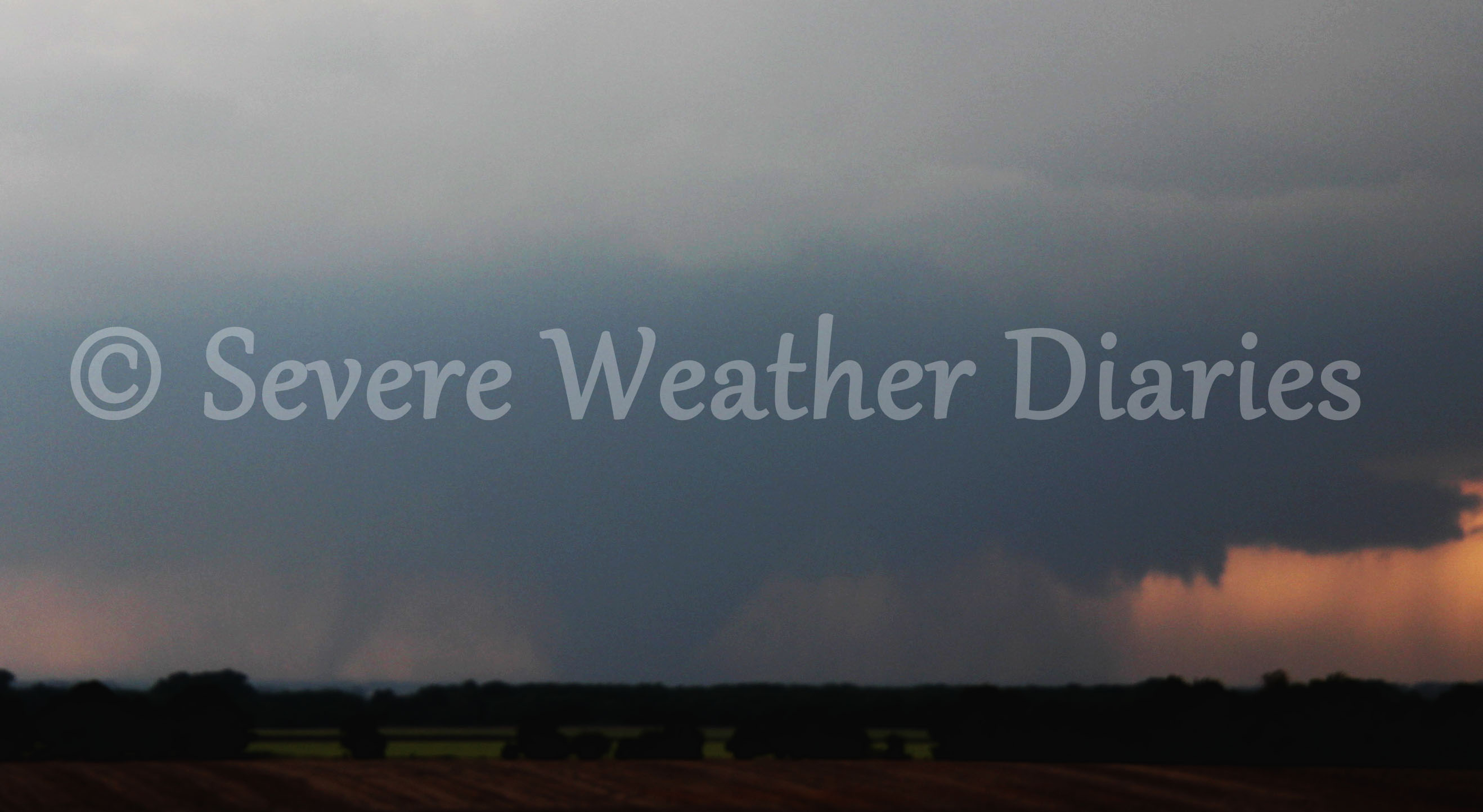 Quickly enhanced image of wedge tornado today near Bennington, Kansas.
We started off in Hays, Kansas this morning and let's just say that the risk for tornadoes was there but very wide spread. I think someone calculated that the 5% tornado risk issued by the SPC was about 5000 square miles?
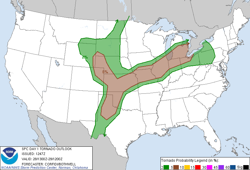 SPC's 1300Z tornado risk from this morning (May 28).
Narrowing down a target was going to be difficult but we decided headed south toward Great Bend, Kansas would put us in play for southwestern Kansas target or north-central Kansas target. En route to Great Bend we saw the CU-field (cumulus field) taking shape to our east and north. We quickly had a bite to eat and headed northeast toward Salina, Kansas.
We saw a couple of towers go up and fizzle out but then Bill Hark (Dr. Wedge, as we call him) saw a towering cumulus in his rear view mirror and decided that was the one!
We watched it grow and headed north so we were southeast of Bennington and Minneapolis, Kansas. The tower grew into a massive supercell and we saw it produce a well shaped funnel cloud. We pulled over and watched and it was really starting to get its act together. Our group split at that point as the more hail-shy chasers moved east and south to stay out of the hail. As we got south a very large tornado formed.
At first this tornado was a very large cone and it was moving in and out of the rain. Eventually it formed into a massive wedge tornado and we watched it as it remained almost stationary for 30 minutes! The storm was just not moving like a traditional supercell would and eventually it just became too immersed in rain. If this supercell had tracked like a traditional storm would, we would have been in closer and perfect position but alas every storm is different.
In hindsight we could have stayed in our original position and been fine but hindsight is 20/20 and we still managed to see the tornado. So far we've heard of some damage but no deaths or injuries and I hope that doesn't change. The tornado did stay south of the towns which we're thankful for.
And finally some NEW PHOTO GALLERIES ADDED - Check them out here: 2013 Storm Chase Pictures
Two new videos added from our May 26 chase day with incredible structure:
I will try to get some more uploading done tonight but the internet here is hit or miss and we have a few long days of chasing ahead of us this week before we head home for the weekend.
May 27 - Chase Day 12 - A Bust ... Kind Of
Hello from Hays, Kansas!
We started the day off in Kearney, Nebraska and headed south toward Plainville, Kansas. The better dynamics for tornadoes was south where we were but this massive supercell developed right along the Kansas-Nebraska border near Smith County, Kansas. The TIV actually got into that tornado (Tornado Intercept Vehicle) which is actually a pretty terrifying video.
Storms did fire where we were and developed a couple of wall clouds but did not produce. We called it a chase and headed to Hays for the night.
Tomorrow is a very difficult forecast as there are a LOT of target areas. We'll see what it brings!