


May 30 - Storm Chase 2019 Round Up
Hello from home!
That was a long two days on the road... and also a long two weeks chasing! Honestly, the first chase day of the trip feels like eons ago. Here are some stats from the trip...
- Dates: May 15 - May 30
- Days Spent: 12 chase days, 2 'down' days
- Driving: 10,600 km (6,600 mi)
- Tornadoes: 5 confirmed visually, 4 'maybe'
- May 17: McCook, NE - NWS Report
- May 17: Farnam, NE (could not visually confirm ground contact from our location) - NWS Report
- May 20: Mangum, OK - KFOR Report
- May 22: Henryetta, OK - NWS Significant Weather Map
- May 22: Henryetta, OK - NWS Significant Weather Map
- May 26: Wiley, CO - Raw NWS Reports
- May 27: 3x Wray, CO (could not visually confirm ground contact from our location) - Denver Post
- 12 States, 1 province (*chased in these States):
- Ontario, Michigan, Ohio, Indiana, Illinois, Missouri, Kansas*, Oklahoma*, Texas*, Colorado*, Nebraska*, Pennsylvania, New York
- Chased the first week in our vehicle with Brad Rousseau and George Kourounis
- Chased the second week in our vehicle with Brad Rousseau (George had to leave earlier for prior commitments)
- First half of the trip was more tornado-heavy than second half
- Chased in convoy with:
It was a long trip with a lot of chase days so there wasn't a lot of opportunity to edit photos and videos. I'll be doing that over the next several weeks and will post them here and on social media when they're done.
 Dayna Vettese
May 29 - Damage in Lawrence, Kansas
Hello from Richmond, Indiana!
This morning we made our way from Topeka to Lawrence, KS to take a look at the damage from the tornado the day before. It was devastating... to say the least. As of right now, no reported fatalities with the tornado which is astounding! We were able to zigzag our way through the neighbourhoods with the worst damage. We didn't linger or loiter as emergency crews were working to clear the area of debris and fix power lines. From what we were able to see, it looked like high-end EF3 tornado damage. At times, the path was wide and others, narrow. A house would be almost destroyed and the next door neighbour virtually untouched.
We wanted to make it to Dayton, Ohio but that town was also devasted by a tornado the other day so all the hotels are booked (righfully so) with people whose homes are damaged. So we stayed one town west in Richmond, IN.
Update: Both the Lawrence, KS and the Dayton, OH tornadoes have been rated EF4.
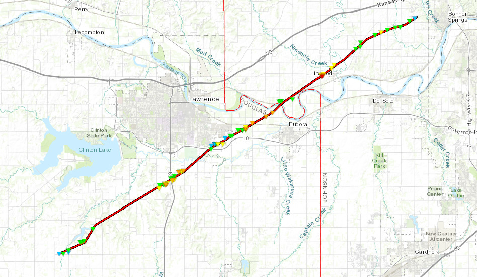 Path of the Lawrence, KS EF4 tornado via NWS Topeka.
May 28 - Kansas: Busted, Big Time, Yeeeaaah
Hello from Topeka, Kansas!
Today was a rough day... we started the morning off in Colby, KS and headed south and east toward McPherson, KS. The setup was such that the warm front would most certainly produce tornadic, but messy storms; hard to chase. There was also a dryline set up across central Kansas and we decided that would be our play. Fairly consistently, the high resolution models were breaking out a couple of storms in and around the Wichita, KS area.
The day progressed and storms would go up then quickly die. We couldn't understand why the storms weren't flourishing in the environment they were in. A storm started going up near Wichita and showed some promise so we stayed with it but it ended up dying. Then... we start seeing the reports out of Mitchell County, KS, northwest of Salina... big tornado on the ground. We were gutted. We had literally driven through that area and that area was forecast to be behind the front. Turns out, some of the ongoing convection had nudged the position of the front just enough that that area was in a great environment. It was too far for us to get there. So... we waited and another storm went up near Wichita and this time it looked good! It produced a wall cloud and a funnel but then quickly became linear and lost all rotation. The day was done for us...
Then we started hearing about awful damage in and around Lawrence, KS. A big tornado had gone through the area and there was a lot of damage.
This was our last chase day of the trip and we wished it could have ended a little more exciting for us but alas, we ended on a bust. We'll be making our way to Topeka, KS tonight. We'll likely take a look at some of the damage in Lawrence then start our trek home.
May 27 - Colorado & Nebraska Storms & Hail
Hello from Colby, Kansas!
We started the day in Burlington, CO and essentially hung out there until late afternoon. We had a bit of a conundrum... chase up near the low in northeast Colorado, into Wyoming and the Nebraska Panhandle, or gamble on storms firing further south into western Kansas. We basically placed ourselves in the middle until the weather forced us to make a decision. A storm went up west of Wray, CO so we headed north out of Burlington to meet up with it.
As we rolled through the hills of northeast Colorado, the storm began to rotate and form an impressive wall cloud and likely a funnel cloud. We continued north on the 385 to keep up with it toward Holyoke then let it cross the road in front of us. The storm was rotating still and had very large hail in it. Road networks were sparse so we had to let it cross the road and follow in behind it.
We slowly progressed east along the 6 toward Lamar following in behind the storm. We had to play tag with the core as there was no way we could punch through it without getting our vehicle destroyed. Up ahead in the core, golf ball and tennis ball size hail was falling. Eventually the core and the area of rotation passed north of highway 6, we continued east to watch. It was very hard to note any features in the core because of the hail and rain but a few suspect areas were showing up every now and again. From the other side of the storm and in the notch, people reported a tornado. We watched the storm head north then it began to weaken. Some people further away from the storm had incredible view of the structure but we just couldn't get there in time because we had to wait for the core.
We decided to call it a chase and head for Colby, KS for the night to position for tomorrow. On the way, as the storms moved off to the north, we got a beautiful structure and lightning display so we stopped to do some photography.
Tomorrow we'll likely head to Salina, KS then assess from there where to go. After that, we're going to proceed home to end off the chase trip.
May 26 - Colorado Tubes
Hello from Burlington, Colorado!
We started the morning in Dodge City, KS and headed west and north to Lamar, CO. We saw storms fire east of meandered that way to watch them and they dissipated. Today was very messy and convection was firing all at the same time. We went back west to Lamar then north out of there toward a good looking storm near Wiley and as we got on it, it produced a very quick tornado. We continued with it but then it dissipated so we headed back south toward another good looking storm. When we got to it, it produced several fantastic wall clouds but the road network was poor so keeping up with it was difficult.
We continued north but there was a lot of hail in the way between us and a view of the business-end of the storm. We thought we saw something back in the hail but couldn't tell. However, some chasers reported a tornado in there so I guess that was it?
Tomorrow... what to do tomorrow... We chase the High Plains of Colorado into Wyoming or the dryline in Kansas...
We'll see what the morning brings!