


May 17 - Chase Day 3 - Storms in Northern Nebraska
Hello from North Platte, Nebraska! Today was interesting but tomorrow … tomorrow will be an intense chase day. But first, today:
We drove north from Colby, Kansas to Valentine, Nebraska with Chris Kridler. There were several targets today but we chose the northern target knowing we needed to be in position for tomorrow’s big chase. We met up with Scott McPartland and Dave Lewison in Valentine! Great to be chasing with them. They will be live streaming this trip (with audio) at the following link: Severe Weather Video Live Stream
Storms started initiating and one started to grab our attention. We drifted north just out of Valentine to get a better look. The cell start to take on a supercell shape and was rotating with a nice inflow tail … then it started to go linear. We eventually left what was left of the cell and headed back south, south of Valentine. We pulled over to do some photography and timelapse of the shelf cloud which was pretty. We headed back south toward North Platte, Nebraska to spend the night and get in position for tomorrow.
Here are pictures from today: Storm Chase 2013 – May 17 – Chase Day 3: Storms in northern Nebraska photos
I’ve also edited a videos from yesterday's chase and today found here on the video page: Storm Chase 2013 Videos
Now … on to tomorrow! The SPC has issued a MODERATE RISK for the area we were initially targeting. This is the first substantial, known-well-in-advance severe weather outbreak so far this season which means EVERYONE will be out. We will reassess the forecast tonight to nail down a target area but looks like we’ll be heading back into Kansas.
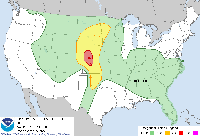
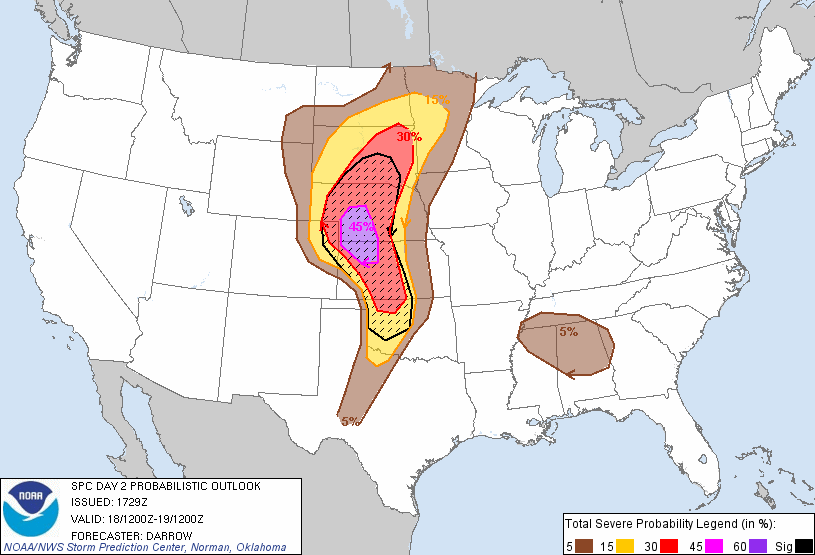
Reading the NWS Dodge City, KS WFO discussion with some very strong wording:
NATIONAL WEATHER SERVICE DODGE CITY KS
1052 PM CDT FRI MAY 17 2013
...
NOW TO THE TORNADO THREAT -- THERE IS REASON FOR GREAT
CONCERN ABOUT THE POSSIBILITY FOR LONG-LIVED, SIGNIFICANT TORNADOES
IN AN ENVIRONMENT THAT IS CHARACTERIZED BY SURFACE-BASED CAPE IN THE
3500-4500 J/KG RANGE ALONG WITH 0-1KM AGL HELICITY RAMPING UP TO THE
300-400 J/KG RANGE AS WELL (THANKS TO THE DYNAMIC LOW LEVEL JET THAT
DEVELOPS JUST AFTER SUNSET). THIS IS A TREMENDOUS AMOUNT OF
POTENTIAL ENERGY BOTH FROM KINEMATICS AND THERMODYNAMICS TO SUPPORT
EXTREMELY STRONG LOW LEVEL ROTATION IN SUPERCELL
THUNDERSTORMS...INCLUDING LONG-LIVED AND STRONG TORNADOES THAT
THRIVE DURING THE POST-SUNSET HOURS. THERE MAY ONLY BE ONE OR TWO
STORMS THAT THRIVE AFTER SUNSET...BUT THE DAMAGE POTENTIAL COULD BE
GREAT FROM JUST ONE ISOLATED SUPERCELL STORM.
Tomorrow will be an interesting day ... time to get some sleep.
 Dayna Vettese
May 16 - Chase Day 2 - Thunderstorms in NW Kansas
Hello from Colby, Kansas! Great to be back on the flat plains of western Kansas. We started our day very early since we had a lot of ground to cover: from Ardmore, OK to Colby, KS which is roughly 8 hours of driving (not including stops for gas, food and stretching). We had a quick bite in Ardmore, OK then hit the road heading north toward Oklahoma City then gradually northwest toward the Oklahoma panhandle.
Our target was west-central Kansas and it would put us in position for Friday's severe weather then the big stuff on the weekend.
From there we headed north into Kansas toward Liberal then north to Garden City, KS. We stopped there for lunch (Subway, what else) and reassessed the target. Storms were initiating right on the Nebraska/Colorado/Kansas border and moving toward Colby, KS. We headed north to Oakley, KS then north toward Colby, KS and played with the storms there. They weren't tornadic but boy did they have some great lightning! They also had some sizable hail (not as big as Texas the previous day). Since the threat of tornadoes was nil, we wanted to get "cored" by the storms. We found an amazing shelter and waited for the core ... and of course it *just* missed us to the north.
New pictures uploaded to the website found here: Chase Day 2 - Northwestern Kansas
New video uploaded to the website found here: Chase Day 1 - North-Central Texas
I have finished editing my video from our first chase day but every time I attempt to upload it the video fails ... Must be the hotel internet. I'll try again tomorrow evening if I can.
Calling it quits for today we headed back to Colby, KS for dinner and to spend the night. We ate at a place called Montana Mike's and it was pretty good. Chris Kridler will be joining us here tonight and then tomorrow we meet up with Scott McPartland and Dave Lewison.
Tomorrow looks like we have a loooong haul ... into Nebraska. Forecasting now and assessing a target.
May 15 - Chase Day 1 - Messy & Dangerous Storms in North-Central Texas
Well, we have our first chase day under our belt this year … And it was a bittersweet chase.
We started the morning off in Norman, Oklahoma, grabbed some breakfast then headed southwest into Texas with a target of Vernon, Texas. When we woke up in the morning the Storm Prediction Center had issued a Slight Risk area and a 5% tornado risk for our target area. We reassessed a bit and headed to Electra, Texas. We then headed over to Seymour, Texas and played the waiting game.
After about an hour and a half we saw towers going up to our east. We left Seymour and headed west to the cells and watched them grow before our eyes. Soon enough we were dealing with full blown supercells. Cells way to our north and way to our south were tornado warned and we knew the environment was conducive to tornadic supercells.
Eventually the cell we were on became tornado warned and several times it developed interesting features. It was slightly disorganized which made visually identifying features difficult. The cells were also rapidly become rain- and hail-wrapped.
We bailed south down a highway toward Decatur, Texas then northeast along another highway our of Decatur. We parked on top of a hill and watched the cell head in our direction. Things started to get interesting at that point and there was definitely a wall cloud developing. The issue? Rain and hail were starting to wrap around it so we headed south back to Decatur. From there we slowly headed east along the 380 … Slowly being the optimal word. We new the cell was drifting southeast and the circulating part of the storm was going to cross the highway. We did see another lowering area develop just to our northeast but it eventually faded. A tornado was reported twice on the cell we were on but it was difficult to say. There were some interesting features but were definitely not tornadoes so to the amateur-eye it may have looked like a tornado. Our cell tried and tried and tried but eventually it just couldn’t hold on anymore and we called it a day. We did meet up with Mark Robinson and Jaclyn Whittal on the side of the highway under the meso!
I’ve uploaded pictures to the photography page and am in the process of editing today’s video. I may not be able to get to it tonight since it’s almost midnight and we’re still a ways from the hotel.
All while this is happening, further to our cell, large, dangerous supercells were moving through towns west of Dallas-Fort Worth area then into the metropolitan area. We’re hearing preliminary reports of damage, deaths and possible mile-wide tornado. These reports are all preliminary and we’re hoping for the best but we’ve seen some damage and tornado pictures and it doesn’t look good. Images of damage and tornadoes coming out of Granbury, Cleburne and Rio Vista, Texas.
Overall, in our neck of the woods, we had a successful first chase day. We’re now headed to Ardmore, Oklahoma to spend the night. We wanted to make it back to Oklahoma City but we’re pretty tired. Tomorrow’s target looks … far … from where we are. Based on tonight’s models perhaps a 6+ hour drive to target tomorrow. We’ll see how things progress.
May 14 - Travel Day 2
Hello from Norman, Oklahoma! We finally made it!
We left Eureka, Missouri this morning at about 10:00am CDT after having our first storm chaser breakfast at Denny's. We made good time driving and were able to stop in Joplin, Missouri to see how the town has been recovering since the devastating EF5 tornado in 2011. The town seems to be rebuilding well and we even noticed some of the new homes have solar panels installed. You can pretty much determine where the tornado tracked based on old homes versus new homes.
Check out the photography section for some new photos added. I have also edited and uploaded a quick video highlighting our journey down found below or in the video section.
We ate dinner with Dan Shaw, Australian storm chaser (check out his website here: SevereStorms.com.au) at On the Border restaurant. Looks like tomorrow we'll be headed toward the Childress, Texas area for our first chase day! It's not the ideal set up but there's a chance and we're taking itl
May 13 - Travel Day 1
We made it - part of the way - and in good time! Hello from Central Time Zone and Eureka, Missouri. We left this morning at about 7:00am from the Toronto area and picked up Greg from his house. We made good time through the Detroit border crossing where, as usual, the border guard was poking fun at us.
From Detroit we headed south to Toledo, Ohio where we picked up out internet hot spot. This time it was quick and painless! Seems to be working (for now) but we all know how the signal is in Tornado Alley ... Well, if you don't, it's BAD!
After that we headed south then west again into Indiana, Illinois then finally Missouri to spend the night.
We're mulling over the forecast now from the comfort of our hotel room. Surprisingly the internet is pretty fast in here! The plan for tomorrow is to continue southwest into Oklahoma and see what's doin' in the wacky world of weather.
Good night, everyone. Apologies for the less-than-interesting update. Travel days are usually ... well ... lack luster. It was a fun car ride down though! Should be a fun chase with Brad and Greg. Can't wait to meet up with the rest of the chasers out here.