
Comments Off |  Share Article
Share Article 


Dayna Vettese Hello from Midland, Texas!
We started our day off in Abilene, TX and after some breakfast, we began our trek southwest along the I-20 toward Midland, TX. This was our "target" to start the day to get us into position for storms to fire. After waiting at a gas station in Midland for a couple of hours, storms began to develop near the NM-TX border. We started vectoring southwest toward Pecos, TX where the storm was.
The storms today had BIG hail so we needed to be very careful about avoiding the cores. We positioned ourselves just southeast of Pecos, TX to watch the storm. It had a lot of rising motion and rotation as well as a very hefty core. We pulled off and watched it for a while and sure enough, we got a funnel cloud and then a tornado! It was brief, only on the ground for a minute or two, but a tornado nonetheless. It was probably one of the oddest tornadoes we've ever seen which is demonstrated in the video timelapse below shot by Dave Lewison today.
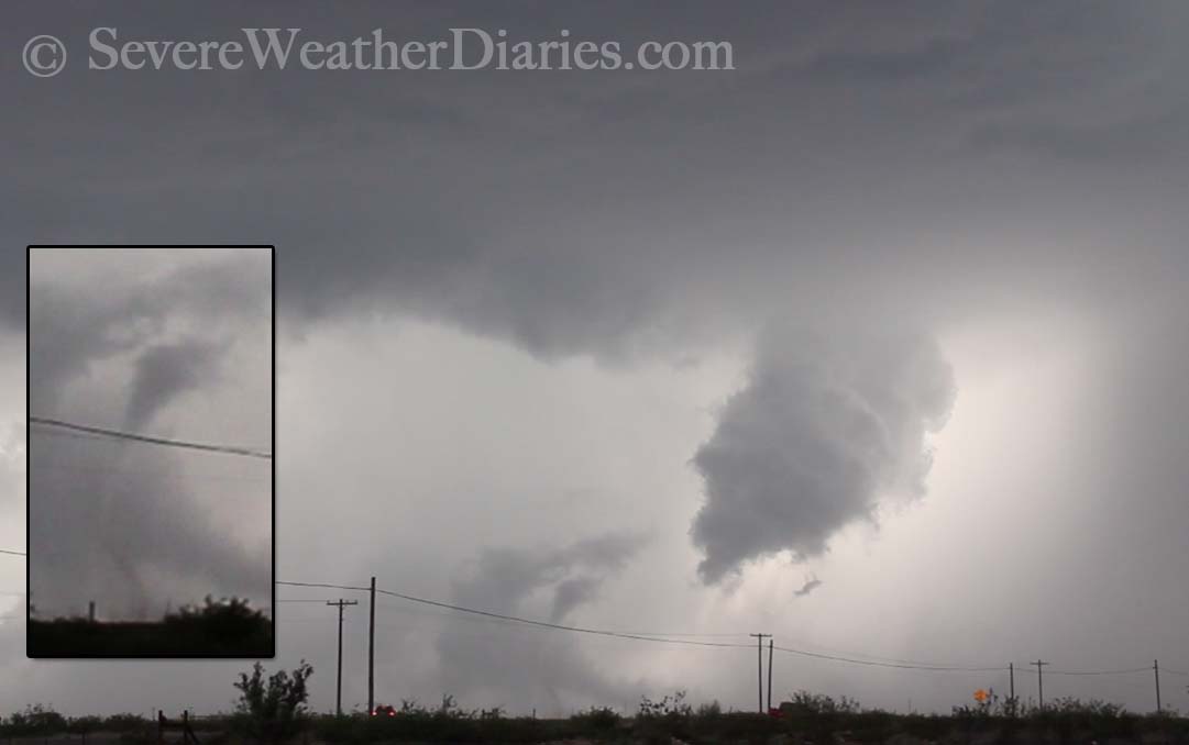 Quick grab from video I took today of strange looking tornado today (May 18) near Pecos, TX.
It was the only tornado report in the United States today.
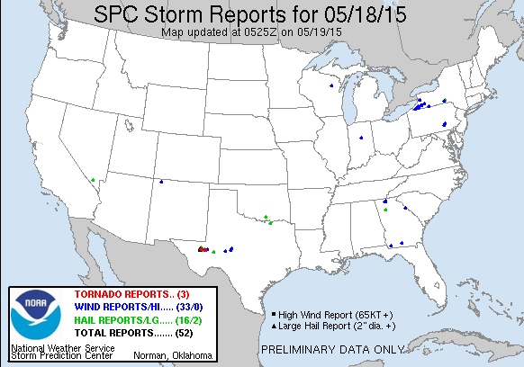 The Storm Prediction Center's storm reports for today (Monday, May 18).
After it lifted, the lightning danger really started to increase. For the remainder of the day we kept along with the storm. It wasn't moving particularly fast so we'd stop, shoot some video and take some pictures, then the core of hail and rain would start to catch up on us and we would reposition again. We continued like this until about 7:30pm CT. What sealed the deal was a very close lightning strike so we got in our cars to start our journey to Midland, TX where we're spending the night.
The lightning show on the way home was incredible. Just an amazing amount of cloud-to-ground lightning like I've never seen before. We got into the hotel fairly late and I'm currently dumping all of our videos and images onto the harddrive as I type so I don't think I'll be able to edit and post any photos or video from today. Luckily there is the video above by Dave which illustrates some of what we saw today.
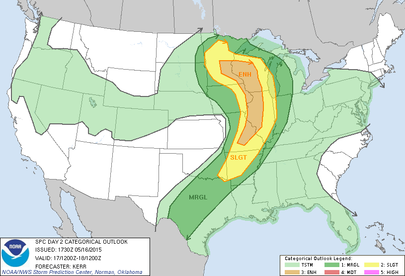
Tomorrow holds a risk for storms again in and around this area so we won't have far to go!
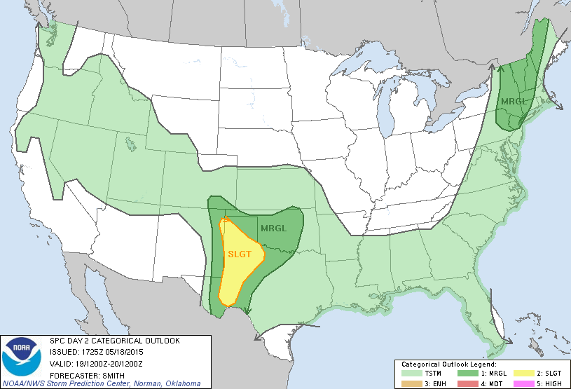 The Storm Prediction Center's thunderstorm risk for tomorrow (Tuesday).
Share Article Dayna Vettese Hello from Abilene, Texas!
Not much to report today. We woke up in Norman, OK and had some breakfast. After hanging around the hotel for a bit we decided to position ourselves south in Texas to get into position for the next couple of chase days. We headed south for Abilene, TX, had some dinner at Abuelos (great restaurant), did some forecasting and are going to get some sleep.
Tomorrow looks like a marginal chase day in southwest Texas which is where we'll be.
 The Storm Prediction Center's thunderstorm risk for tomorrow (May 18).
Share Article Dayna Vettese Hello from Norman, Oklahoma!
What a day... 500 miles of driving for a somewhat rotating wall cloud. That's storm chasing, I guess. We started off in Colby, KS and started the drive south. It was a very widespread risk of storms today so trying to nail down a single location proved to be a difficult task.
When the storm started to fire things got messy fast. Initially we were aiming for Woodward, OK toward Greensburg, KS. As we continued south we monitored satellite, observations and radar and adjusted south. We kept stair stepping south into Oklahoma and then the beast-o cell took shape right along the Red River in southern Oklahoma. It was very far from where we were but we tried desperately to get to it in time. It put down a massive tornado that went through Elmer and Tipton, OK.
We dropped south to the Anadarko, OK area. By the time we got there, the storm was still rotation and it had a wallcloud but no tornado. It quickly became wrapped up in rain and was difficult to see anything. We admitted defeat for the day and headed to Norman, OK to spend the night.
New photos have been added to the photography section here.
Tomorrow is a marginal risk day for storms, we aren't expecting much likely headed into western or southwestern Oklahoma. Then again, we didn't expect much the day we saw the tornado near Guthrie, TX. Sometimes the marginal risk days are the best days.
 The Storm Prediction Center's thunderstorm risk forecast for tomorrow (May 17).
Share Article Dayna Vettese Hello from Colby, Kansas!
What a day… We’re all exhausted. It’s about 2:30am CT. Originally we thought we’d make it into the hotel by just after midnight but unfortunately one of our chase friends hit a deer and her vehicle was rendered un-driveable. More on that in a moment…
We started the day off in Dodge City, KS. Getting up very early we made our way north with our goal of setting up shop in Lexington, NE (our ninth state of the trip!). When we rolled into town, we met up with Scott McPartland, Dave Lewison and Stephen Barabas! They just finished their very long journey from New York and Connecticut. We hung around in Lexington for a while waiting for storms to initiate. They were firing in north-western and western so we decided to head west making our way along the I-80 and hung around in Big Springs, NE, very close to the Colorado border. We had a few storms in the area showing rotation.
To our south was a storm showing very evident signs of rotation. We saw it produce several wall clouds and possibly a funnel. We repositioned south to get a better look. At that point, the storm started to “gust out” and become outflow dominant which produced a beautiful shelf cloud and lightning show. We started back east along highway 30 so we could keep ahead of the shelf cloud and get some pictures and video (and stay safe with all the lightning). Just around the town of Roscoe, NE we found a great spot up on a hill with a clear view of the storm. We set up our tripods and cameras and let them roll.
It started getting late and we had a very long drive to our hotel for the night in Colby, KS. We stopped off in Sutherland, NE to gas up and the attendants were nice enough to make us pizza! Most of our convoy continued south on highway 25 but Chris Kridler stopped to continue doing some lightning photography. We also started south but them pulled over once we saw how amazing the lightning was lighting up the updrafts of the thunderstorms to our north and west. After some time doing photography, we began south.
If you’ve never driven highway 25 in Nebraska, or ANY highway at night in Nebraska, it is one of the scariest experiences. Towns are few and far between and deer are EVERYWHERE! We came across many deer with Brad, Matt and I all keeping an eye in the fields around us. Several times we had to slam on the brakes coming across deer along the road. We started closing in on the town of Trenton, NE when we got a message from Scott McPartland saying Chris Kridler had hit a deer and they were all pulled off. We found their convoy pulled off and pulled over with them.
Thankfully, Chris was okay; shaken up but unharmed. Several other chasers were there with us including Daniel Shaw. Unfortunately Chris’ vehicle was heavily damaged and could not be driven. She was able to spend the night in McCook, NE and will be dealing with the items today in North Platte, NE.
By this time it was midnight so we continued our drive south to the hotel. We pulled in at about 2:00am CT and are in the process of crashing into bed.
Tomorrow looks like another big chase day. The Storm Prediction Center has issued a MODERATE risk for storms with a 15% hatched area of tornadoes that stretches from the Red River in southern Oklahoma all the way to North Platte, NE; big area to cover. One thing’s for sure, we will NOT be chasing anywhere near the Oklahoma City metro or south-western Oklahoma. With the imminent and guaranteed traffic jams plus the oversaturated terrain, there are bound to be too many chasers on few and flooded roads… No thanks.
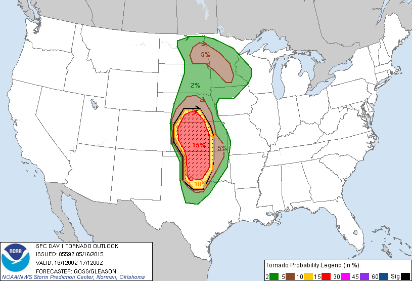 The Storm Prediction Center's tornado risk for tomorrow (May 16).
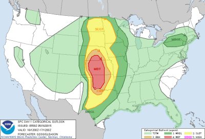 The Storm Prediction Center's storm risk for tomorrow (May 16).
Share Article Dayna Vettese Hello from Dodge City, Kansas (again)!
We started the day in Lubbock, TX and really, the target for today was... well.. Lubbock, TX. Our one main concern was, yes, the environment looked good for storms in our area for today BUT tomorrow (Friday) looks to hold very good storm potential in... well... Nebraska and that is a loooong way from where we were in Texas. We decided, if by 4:00pm CT things weren't looking to get going soon in our area, we were going to start our journey north. Sure enough, things still hadn't fired by that time so we started venturing north. Our target for sleeping was Dodge City, KS which was about a five to six hour drive from where we were.
We hit the road and essentially didn't stop until Dodge City, KS (except for a photo op or two near the Caprock and gas along the way). We pulled into Dodge City at around 11:00pm CT and managed to grab a bite to eat.
We're up very early tomorrow to continue north into Nebraska - our 9th state this season. Tomorrow currently holds an ENHANCED risk for storms. Saturday also holds good potential back in this region.
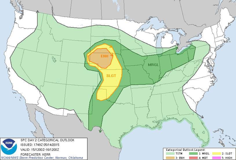 The Storm Prediction Center's risk assessment for storms tomorrow (Friday).
Share Article