
Comments Off |  Share Article
Share Article 


Dayna Vettese Hello from Clinton, Oklahoma!
We started the day very, very early in Warrenton, Missouri. After a quick breakfast, we headed west on the I-70 into Kansas. Once there, we jogged south on the I-35 toward Wichita, KS. As we approached Wichita, we re-assessed the forecast and decided we needed to head a bit farther south; the environment in southern Kansas was just too worked over from morning convection.
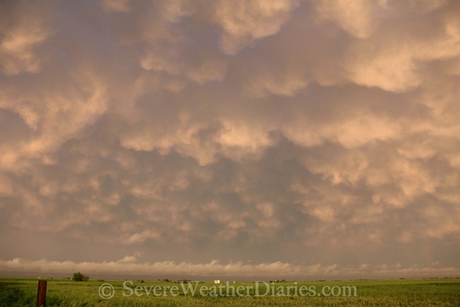 Sunset mammatus from El Reno, Oklahoma.
We continued south into Oklahoma and headed toward the Guthrie area... Breaking our rule about never getting close to the Oklahoma City metro again to chase. We ended up in the Piedmont area and were on a storm but quickly things were becoming messy, rainy, and disorganized. We tried to race east then south to get ahead of the cluster of storms but we just couldn't make it. Not to mention Oklahoma City was flooding again... Oklahoma City in just four days went from about 0.5" inches below their normal year-to-date average to the wettest on record since the late 1940's.
We decided to make our way west to our hotel but stopped to do some photography once we got to El Reno, OK. It was eerie being in the exact same spot we were on May 31, 2013 watching the monster barrel toward us. This was a much more serene experience as a setting sun cast the perfect lighting on the storms in Oklahoma City, rainbows and mammatus. Photos have been uploaded here but I haven't edited any video because I just haven't had much compelling video to add (hopefully that changes tomorrow!).
Speaking of tomorrow... MODERATE risk still holds from the Storm Prediction Center. We're refining our target right now. Our hotel spot for the night is strategic as it puts us within reach of multiple targets. It being a Saturday, in May, with a MODERATE risk... There are going to be a LOT of chasers out (including us of course). We'll be sure to play it safe. All risks are on the table including large hail and the potential for tornadoes. We will refine our target in the morning once we've had a chance to look at soundings, observations, satellite and radar.
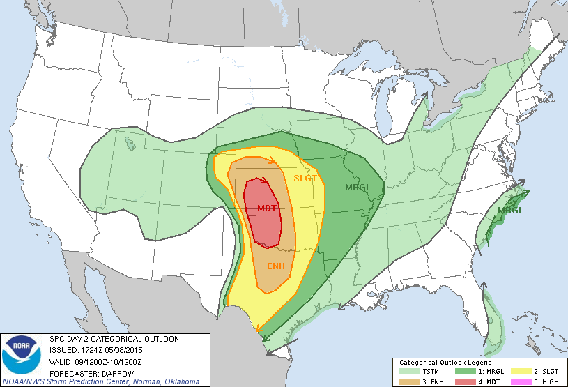 Storm Prediction Center's Day 2 (Saturday) risk outlook.
Oh, note to all chasers: Clinton, Oklahoma has nothing to eat late at night except McDonald's...
Share Article Dayna Vettese Hello from Clinton, Oklahoma!
We started the day very, very early in Warrenton, MO, had a quick breakfast then started to make our way west along the I-70. We continued west until Kansas City where we cut south on the I-35 toward Wichita, KS. Once we reached the Wichita area, we re-assessed and decided to continue further south. The environment in the Wichita area and southern Kansas had been worked over too much from morning convection.
The best area of play was in western Texas but that was just too far for us to make today. Some storms fired west of the Oklahoma City metro and though we vowed never to again... We ventured close to the metro to chase. We found ourselves in and around the Piedmont area but things were rapidly becoming very high precipitation and structurally weren't all that impressive. We tried to get east of the storms to cut south ahead of them but just couldn't make it. It also didn't help that Oklahoma City was flooding once again. They went from being record dry to be record wet in a matter of a week. After deciding to give up on the storms, we started to head west to our hotel for the night.
This path took us past El Reno, OK and that insane day back on May 31, 2013 was actually the last day we had chased in two years! It was eerie being back and being in the same spot we stood while the tornado barreled toward us.
Today was a much different day in that spot... The sun was setting and casting beautiful colours on the storms heading through Oklahoma City as well as causing a couple of rainbows and beautifully lit mammatus. I've now added pictures to the gallery here but haven't edited any video yet. We haven't had too much in the way of compelling video yet but hopefully that changes tomorrow!
Tomorrow is another MODERATE risk day as per the Storm Prediction Center's 18Z update today. We're spending the night in western Oklahoma because it puts us in good position for several potential targets tomorrow. We're refining our target as I type this but will obviously reassess in the morning by taking a look at radar, satellite, soundings and observations.
 Storm Prediction Center's Day 2 (Saturday) risk assessment.
Oh, and note to chasers: there's no where to eat late in Clinton, Oklahoma except for McDonald's...
Share Article Dayna Vettese Hello from Warrenton, Missouri!
We've been on the road since 7:00am ET and pulled into our hotel for the night at 11:00pm ET (10:00pm CT). Our route took us from the northern Greater Toronto Area, picked up Matt, and we headed southwest along the 401. We crossed the border at Detroit, MI then made a quick stop in Toledo, OH where we activated our hot spot for internet and data in the chase truck. All is working well and the electronics seem to be in working order!
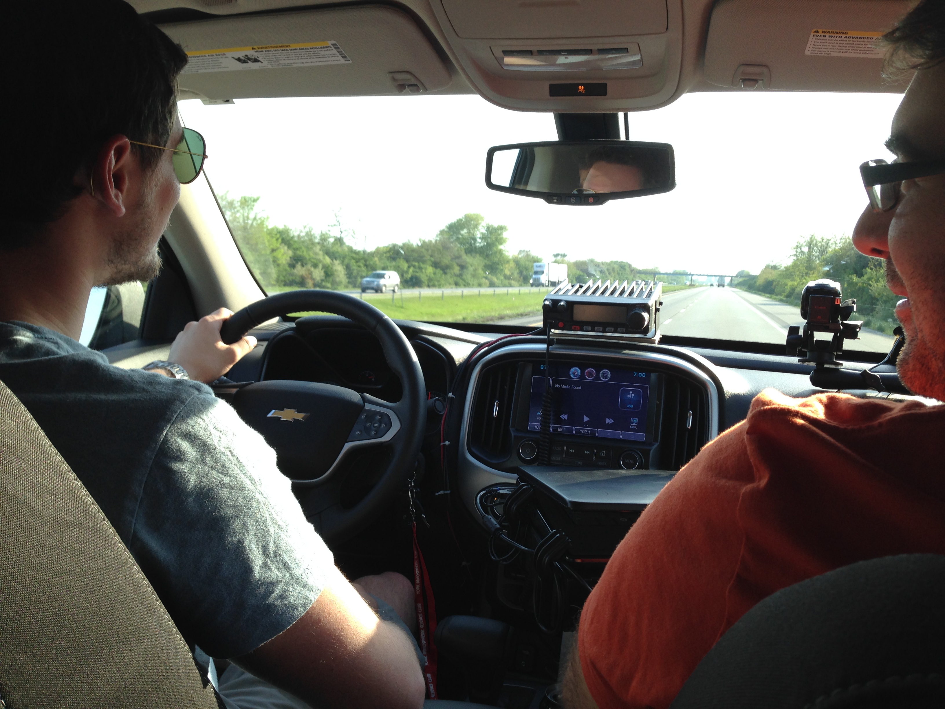 Matt giving the vehicle a spin as we drive through Illinois
From Toledo, OH we continued to may our way south and west headed south toward Dayton, OH then west through Indiana, Illinois and finally our resting place for the night about an hour west of St. Louis, MO.
Things have certainly escalated in terms of the forecast for the next few days. The Storm Prediction Center has put out a MODERATE risk for severe storms tomorrow (Friday) as well as a MODERATE risk for storms Saturday. With a 45% hatched probability area of Saturday, there is a chance it could go HIGH risk.
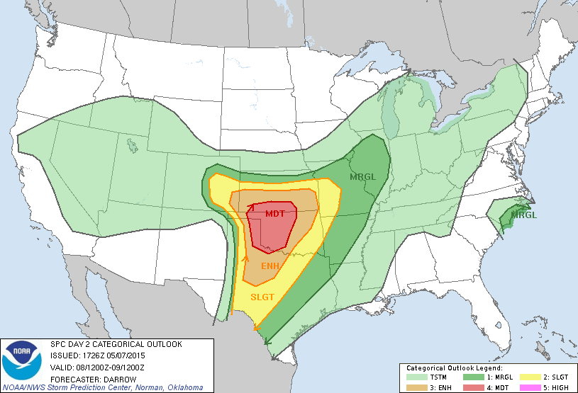 Friday's risk (as of Thursday afternoon) via SPC
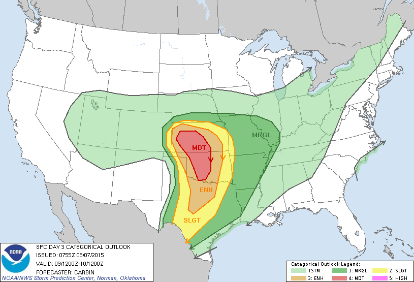 Saturday's risk (as of Thursday afternoon) via SPC
Both days have us particularly nervous but most from a "numbers" standpoint. I don't want to come across as hypocritical because we are out here chasing as well. But it is a concern when they may be quite a large crowd of chasers out especially on Saturday since many folks have that day off. We'll see what happens...
We have an early start in the morning to get into position to chase. Normally we take two days to travel before we start chasing but it looks like our second "travel" day will also involve a chase! We'll refine a target tonight and likely continue west along the I-70 toward Kansas and depending on our thoughts will head for the target. We could have a 6-7 hour drive for us tomorrow so if we want to make initiation (start time of storms) then we need to head out early.
Took some video of us driving through the various States but I'll edit that at a later time.
Share Article Dayna Vettese It's finally here: the week we leave! I've been crazy busy with work and getting things ready to go and finally the day is within reach. Due to work commitments, the earliest we could leave would be the morning of May 7th. We're all ready to go so it's just a matter of pulling the trigger and heading out. There are quite a few "chase-able" days this week so we'll keep reassessing through Wednesday night to see when we should head out.
The journey normally takes us about 1.75 days of travel taking us from Toronto, ON to just west of St. Louis, MO the first day then the second day from that point through to where ever we need to be. In the past, day 2 normally takes us to Oklahoma City, OK. Depending on where storms could set up on May 8th (if the models continue to trend this way) we may end up either heading SW on the I-44 or W on the I-70 on day 2. We'll make that call as we travel.
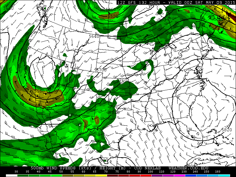 20150503 12Z GFS 500mb Wind Speeds for Friday night (00Z 20150509).If the pattern holds, we should be able to chase on Friday. We likely wouldn't be in position for initiation but should get there in time to see some storms (again, if the pattern holds).
Long range models look promising for May 2015. After this week, looks like there could be a couple of down days but overall the pattern looks to remain active through the end of the month. It doesn't look to be epic setups at this point but certainly troughing in the west... Which is a lot more than what the dominating pattern has been over the last year or so.
Share Article Dayna Vettese We have had the opportunity to chase with veteran and skilled storm chasers and have also had the opportunity to bring people chasing who have never had the chance to before.
 This year our friend, former classmate, and current colleague at The Weather Network, Matt Grinter, will be chasing with us! We've chased with Matt in southern Ontario before but this will be his first trip to Tornado Alley. Matt attended York University with myself and Brad Rousseau. He graduated a couple of years after us with honours with a BSc in Atmospheric Science as well as a Certificate in Meteorology. Matt currently works as a meteorologist at The Weather Network. He is also an adventurer and avid photographer. We're really excited to have him along on the trip and hopefully we can get him some tornadoes (if the pattern cooperates)!
We've made good progress on the chase preps. We figured out a mount for the HAM radio so now it's just a matter of wiring it to the car battery which Brad will do next weekend. The laptop stand was a bit of trouble... Unfortunately there are no mounts for Brad's truck so we've been retrofitting our current one to fit into the cup holder as a mount. Brad has had some luck with it and will continue working on it next weekend as well.
 There are no power outlets in Brad's truck but there are several 12V ports as well as several USB outlets. We purchased a 300W inverter that plugs into the 12V port and have two outlet plugs to plug in. This should be okay for power and we don't forsee running into any power issues such as blown fuses. The inverter would mostly be used to keep our chasing laptop charged. To charge our phones we can pop them into the USB ports. We didn't have an issue with fuses blowing in my vehicle and one laptop should not draw more than 300W.
The long range pattern has been a tough one to nail down! You can't say with any confidence past five days whether there are going to be tornadoes on not but at this point you can get a general idea of where the models are going with the overall pattern. Big troughs, it was we want! Unfortunately the long range models are very "muddy", as Brad puts it, with no real discernable solution. It's frustrating but not abnormal to have outlooks like these that aren't as clear cut. It does look more promising that it did at this time last year for May so there's that... We're coming out of an active pattern after the next few days of severe weather followed by a slow period. After that, things look to pick back up again. The earliest day we can leave due to work commitments is May 7 and we need to return by June 5 so any three week period in there will work.
Share Article