
Comments Off |  Share Article
Share Article 


Dayna Vettese It's been a while! We didn't chase last year, 2014, in the U.S. but from what transpired (or didn't transpire), we didn't miss too much. Granted there were the epic twin wedges in June and several severe tornadoes in April but if we were chasing last year, we would have been slotted for May anyway. So no, we didn't chase last year because we were busy getting married! Remember when Brad proposed in front of the tornado?
We'll be taking a truck down this year so we had a couple of challenges like where to mount the HAM radio as well as what to do for a laptop mount. We sorted the HAM radio problem and wiring it into the truck is a heck of a lot easier than the crossover we took last time. We don't even need to put the wires through the firewall, it fits right through the front consol into the engine area. The laptop stand is an issue though... There's no way to retro fit the current RAM mount we have right now. We can reuse the tray but will need a new way of mounting it. We haven't figured that one out yet. For power we're covered. There are three 12-V power sources and two or three USB ports as well to charge phones.
The earliest we can head down is May 7. Typically it's a two day journey for us making it from Toronto, Ontario to east-central Missouri the first day then through to the Oklahoma area the second day. We could really push it if we needed to get down there but it's not preferred. We'll be out for about three weeks. What's a big pain this year is the Canadian dollar doing so poorly again the U.S. dollar for exchange rates.
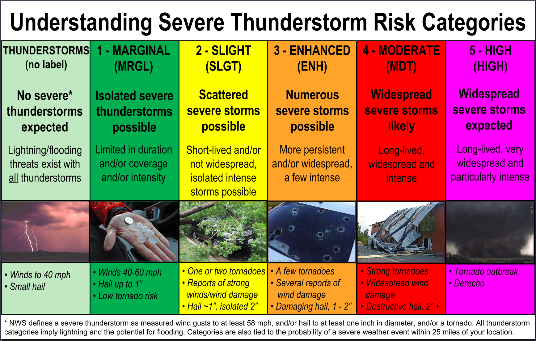
The Storm Prediction Center is using their new severe weather risk categorization scale. Click the image below to be taken to the official SPC page explaining in detail what each category means:
We've been looking at long range models to get an idea of what May might have in store. Usually you can start to form a pretty good idea of the progression of the pattern in May by this time in April. Of course, confidence in the models increases as we get closer to May but we can start to get a very rough sketch right now. It certainly looks more promising than the set up last year... which is good.
A few days of severe weather are ahead for the U.S. this week with Wednesday shaping up to be a classic severe weather scenario through the Plains with tornadoes possible. We'll certainly take this opportunity to practice our forecasting and picking targets. Tomorrow evening I'll try to put together a forecast and pick a target for Wednesday. If you're chasing this week or live in the area, be safe.
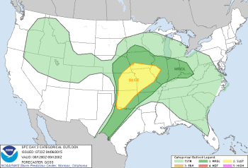 NWS SPC's Convection Outlook for Wednesday
   DAY 3 CONVECTIVE OUTLOOK
   NWS STORM PREDICTION CENTER NORMAN OK
   0233 AM CDT MON APR 06 2015

   VALID 081200Z - 091200Z

   ...THERE IS A SLGT RISK OF SVR TSTMS FROM THE MID AND LOWER MO/MID
   MS VALLEY REGION SWWD ACROSS ERN KS/CENTRAL OK...

   ...THERE IS A MRGL RISK OF SVR TSTMS SURROUNDING THE SLIGHT RISK
   AREA...FROM THE MIDWEST WWD INTO THE MID MO VALLEY...AND SWD ACROSS
   CENTRAL TX...

   ...SUMMARY...
   SCATTERED SHOWERS AND STORMS ARE FORECAST ACROSS A LARGE PORTION OF
   THE CENTRAL AND EASTERN UNITED STATES...INCLUDING AN AREA OF SEVERE
   STORMS OVER THE CENTER OF THE COUNTRY.  SHOWERS AND THUNDERSTORMS
   ARE ALSO FORECAST ACROSS PORTIONS OF THE INTERMOUNTAIN WEST
   WEDNESDAY.

   ...SYNOPSIS...
   STEADY EWD ADVANCE OF A LARGE WRN U.S. UPPER TROUGH IS FORECAST TO
   CONTINUE DAY 3 /WED/.  SUBSTANTIAL HEIGHT FALLS ARE FORECAST TO
   OCCUR AHEAD OF THIS FEATURE OVER THE PLAINS...WITH THE TROUGH
   PROGGED TO REACH/CROSS THE NRN AND CENTRAL HIGH PLAINS LATE IN THE
   PERIOD.  DOWNSTREAM...RIDGING IS FORECAST TO INCREASE E OF THE MS
   VALLEY...AS THE OVERALL PATTERN AMPLIFIES CONUS-WIDE.

   AT THE SURFACE...CYCLOGENESIS IS FORECAST IN RESPONSE TO THE
   APPROACHING UPPER SYSTEM -- INITIALLY OVER THE CENTRAL HIGH PLAINS
   DURING THE DAY AND THEN SHIFTING NEWD TO BECOME CENTERED NEAR THE
   ERN NEB/NERN KS/NWRN MO/WRN IA BORDER REGION BY THE END OF THE
   PERIOD.  S OF THIS LOW...A DRYLINE IS PROGGED TO MIX EWD INTO
   CENTRAL KS/CENTRAL OK THROUGH THE AFTERNOON...TO BECOME OVERTAKEN BY
   A SEWD-MOVING COLD FRONT OVERNIGHT.  MEANWHILE...A NWD ADVANCE OF A
   WARM FRONT ACROSS THE KS/MO VICINITY IS FORECAST WITH TIME AS THE
   SURFACE LOW DEEPENS/SHIFTS NEWD ACROSS KS.

   ...THE MIDWEST/MID AND LOWER MO VALLEY/CENTRAL AND SRN PLAINS...
   A MOIST BOUNDARY LAYER WILL REMAIN IN PLACE ACROSS THE CENTRAL AND
   SRN PLAINS AND MID/LOWER MO VALLEY REGION AHEAD OF THE DRYLINE AS IT
   MIXES EWD THROUGH THE AFTERNOON.  AS HEIGHT FALLS ALOFT OCCUR AHEAD
   OF THE ADVANCING UPPER TROUGH...RESULTING ASCENT WILL SUPPORT
   WEAKENING OF CAPPING AT THE BASE OF THE EML LAYER -- PARTICULARLY
   FROM SRN OK NWD INTO KS.  EVENTUALLY...ASCENT SHOULD PROVE
   SUFFICIENT TO ALLOW LOCAL BREACHES IN CAPPING -- AND RESULTING/RAPID
   DEVELOPMENT OF ISOLATED STORMS.  GIVEN A VERY UNSTABLE AIRMASS/STEEP
   LAPSE RATES ALOFT...AND AIDED BY FAVORABLY STRENGTHENING/VEERING
   FLOW WITH HEIGHT...STORMS SHOULD RAPIDLY BECOME SUPERCELLS.  ALONG
   WITH LOCALLY DAMAGING WINDS...VERY LARGE HAIL IS EXPECTED.  IN
   ADDITION...THE AMPLY MOIST BOUNDARY LAYER AND FAVORABLE LOW-LEVEL
   SHEAR -- PARTICULARLY NWD INTO KS NEARER THE ADVANCING SURFACE LOW
   -- WILL LIKELY BE SUFFICIENT TO SUPPORT RISK FOR TORNADOES.  WHILE
   OVERALL STORM COVERAGE SHOULD REMAIN WIDELY SCATTERED TO
   ISOLATED...SIGNIFICANT SEVERE WEATHER IS EXPECTED WITH ANY STORM
   WHICH DOES DEVELOP.

   OVERNIGHT...INCREASING WARM ADVECTION AHEAD OF THE ADVANCING LOW --
   PARTICULARLY NEAR/N OF THE WARM FRONT -- SUGGESTS INCREASING
   CONVECTIVE COVERAGE.  THIS WILL ALLOW WARM-SECTOR RISK TO
   CONTINUE/SPREAD EWD INTO MO THROUGH THE EVENING/OVERNIGHT...WHILE
   ELEVATED STORMS POSING A LARGE HAIL RISK MAY DEVELOP AS FAR N AS
   NEB/IA/SRN MN...AND EWD INTO THE OH VALLEY STATES.

   ..GOSS.. 04/06/2015
Share Article