
Comments Off |  Share Article
Share Article 


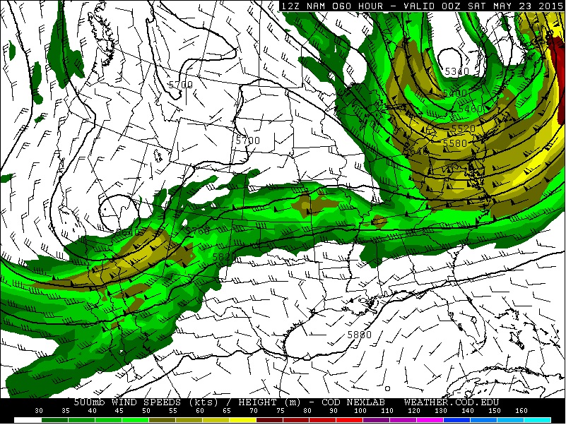
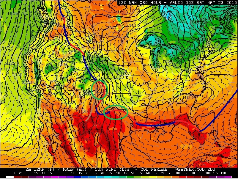
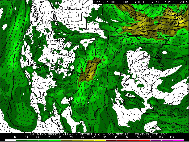
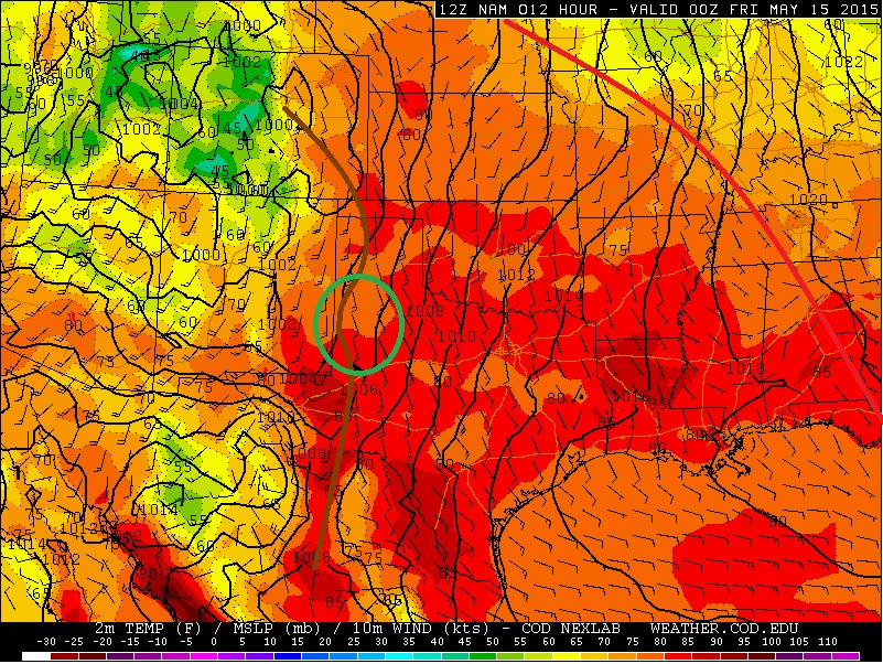
Brad Rousseau There will be the risk for strong thunderstorms across most of southern Ontario for Monday night into Tuesday morning. But I cannot completely rule out the risk for mid to late Monday afternoon for southwestern Ontario. Below is a 4 panel chart where I am showing the June 21 18Z (2pm EDT) NAM which is valid for 21Z (5pm EDT) Monday June 22. Note that I'm merely using the NAM for some visual references when discussing the forecast but will note that there is good model agreement among the NAM/GEM/GFS/ECMWF/SREF with the synoptic scale features. In terms of mesoscale features (i.e. outflow boundaries, confluence regions, lake breeze fronts) those are yet to be determined and will play a key role in the severe weather risk but for now I'll give a broad overview. Back to the 4 panel image from top left going clockwise is 500 mb winds and geopotential heights, 500 mb absolute vorticity and geopotential heights, surface temperature/wind/mslp with analysis done by myself, and 850 mb winds and geopotential heights. We can see we have a 70-90 knots 500 mb jet pushing into northern Michigan over Lake Huron with a 55-70 knot flow through central / southern Michigan and nosing into southwestern Ontario. Looking at the 500 mb vorticity there is a shortwave expected to track through central Michigan near the 5pm EDT time frame. The shortwave is more potent into the Superior East region of Ontario but does exhibit subtle trough through south central Michigan. At the surface the low is expected to be somewhere along the northwestern shores of lake Michigan near the WI / MI border with the warm front drapped through northern / eastern MI into southwestern Ontario. Although precipitation models are not indicating much of a risk at this time, I believe the large scale ascent from the upper shortwave in combination with the advancing warm front may provide enough lift to give the slight risk of some thunderstorms developing through central MI which could push into southwestern Ontario through the late afternoon.
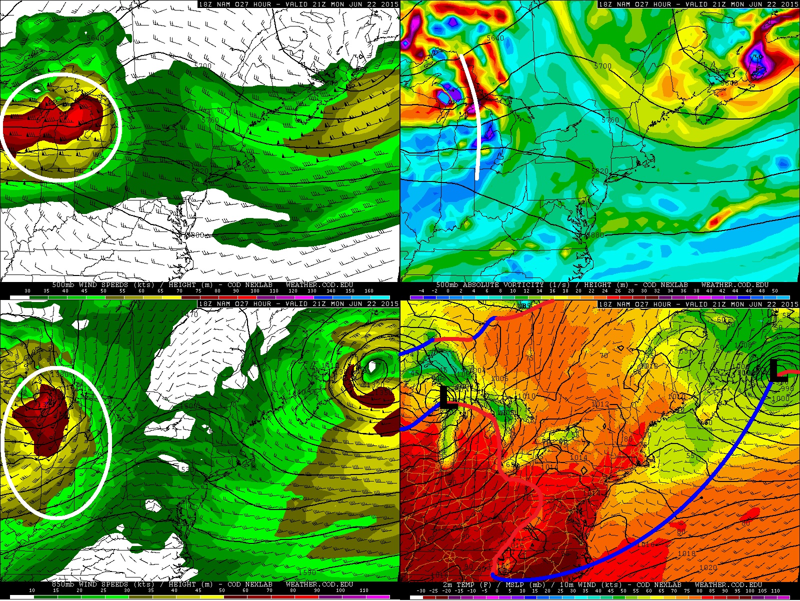
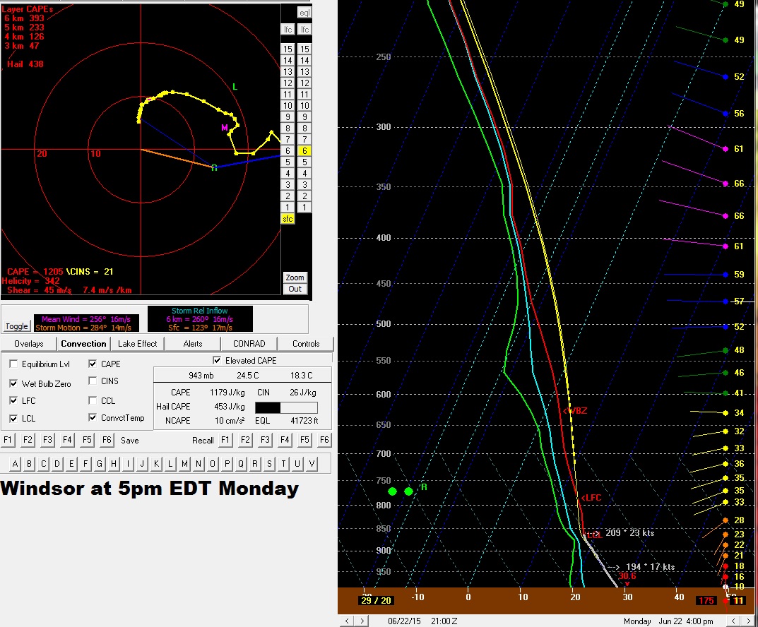
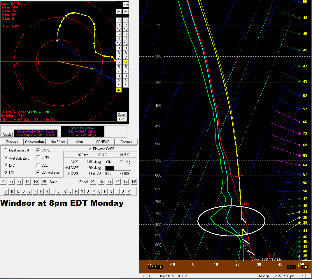
Below are the 5pm and 8pm forecast soundings for the Windsor area for June 22 based off the 12Z NAM from June 21. At 5pm the environment appears to be freely convective with a nice veering wind profile and a large looping hodograph which will be favourable for well organized supercells. By 8pm we can see that there is some higher CIN (Convective Inhibition) building back in (white hatched area) with some weak subsidence between 850-750mb as outlined by the circled area. This leads me to believe that the window of opportunity for mid to late afternoon storms will be near 4-8pm which lines up well with the passage of the upper shortwave and advancing warm front. So given MLCAPE values near 1000-2000 j/kg for southwestern Ontario and 2000-4000 for j/kg for MI, 0-6 km bulk shear near 45-70 knots, 40-50 knots southerly 850 mb LLJ, 200-450 m^2/s^2, and veering wind profiles with large looping hodographs, should any storms develop in this environment discrete supercells will certainly be the primary storm mode with the risk for a few tornadoes. NOTE that I'm not saying this will be the case but that there is just a very slight chance that storms could initiate in this environment given the parameters discussed here. The main risk for Ontario will be limited to the extreme southwest portion which will be Sarnia - Lambton as well as Windsor-Essex-Chatham-Kent regions.
4 panel chart below is the same as the one above but valid for 5am Tuesday morning. It is during the overnight through early Tuesday morning where there is a more certain risk of thunderstorms across most of southern Ontario. Aloft we have the 65-75 knot 500 mb jet overtaking most of central, southern, and eastern Ontario with the primary short wave advacing through central Ontario along with an 850 mb southwesterly to westerly 45-75 knot LLJ. At the surface the low is expected to be within northeastern Ontario north of the Timmins area with the lead cold front surging through central to southern Ontario. There remains some uncertainty with how the cold front will behave through MI as shear vectors do suggest the possibility of more discrete supercells. But current forecast trend looks to favour more linear mode with the advancing cold front. That being said should discrete supercells develop throuh WI / MI it is expected that they will transitions into linear segments or even a large squall line. Regardless it is likely for Ontario mainly a linear mode is expected which will push through the province starting about 10 pm through to Tuesday morning.
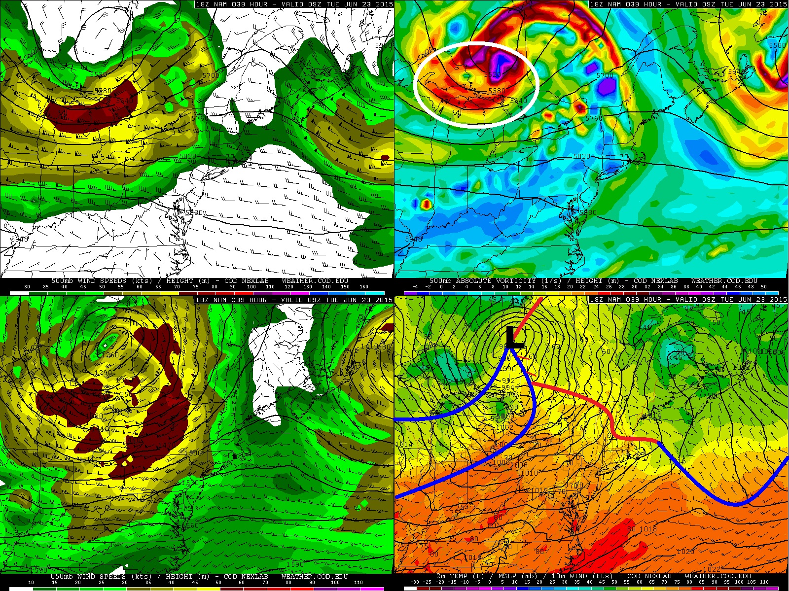
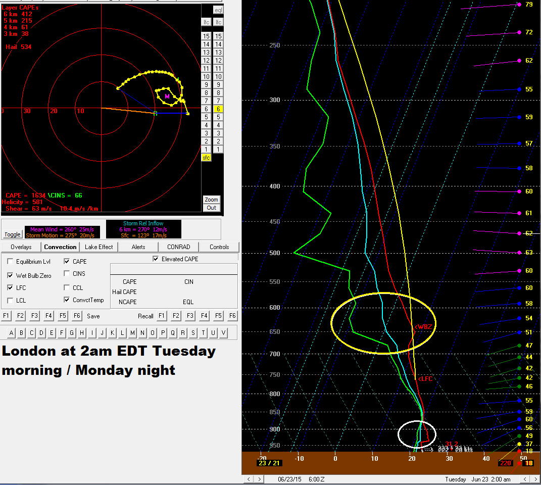
Below is a forecast sounding from the June 21 12Z NAM which is valid for 2am EDT Tuesday morning (Monday night). A couple issues I'm seeing is the low level inversion as indicated by the white circled area and the other is the subsidence layer aloft as outlined by the yellow circle. These features do get washed out through to the 9Z (5am EDT) sounding however. With 40-60 knots of 0-6 km shear and MLCAPE values near 1000-3000 j/kg a strong squall line looks likely for the province with the potential for strong and potentially damaging winds, heavy and possibly significant rain with the risk for some localized flooding, frequent lighting, and small hail. I see the word derecho being thrown around with this event but I hold my reservation on that for the time being given the sounding issues, but with the potent 850 mb LLJ certainly strong and potentially damaging wind gusts are possible.
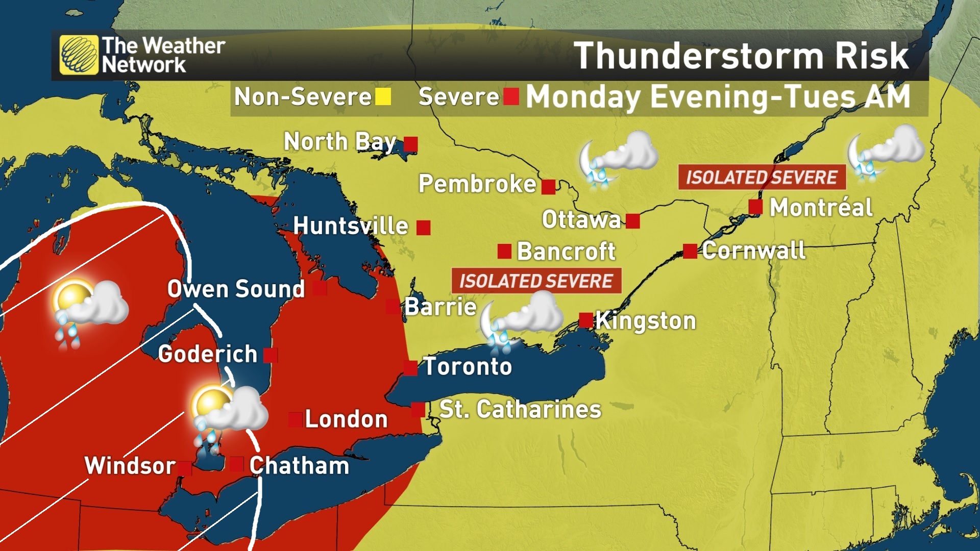
Below is the current risk map produced by The Weather Network. The area in red outlines where the greatest severe risk will be for Monday evening through to Tuesday morning with the yellow area only having a slight risk of a severe storms or two. The white hatched area I added outlines the late afternoon / early evening risk of a couple discrete supercells with a slight tornado threat SHOULD the warm front trigger any storms. NOTE THIS RISK FOR THE WHITE HATCHED AREA IS ONLY A SMALL CHANCE AND THE TORNADO THREAT DEPENDS ON WHETHER OR NOT ANY STORMS CAN INITIATED ON THE WARM FRONT WITH THE LEAD SHORTWAVE THROUGH THE AFTERNOON. THE MORE CERTAIN RISK IS THE MONDAY EVENING/OVERNIGHT POTENTIAL SQUALL LINE.
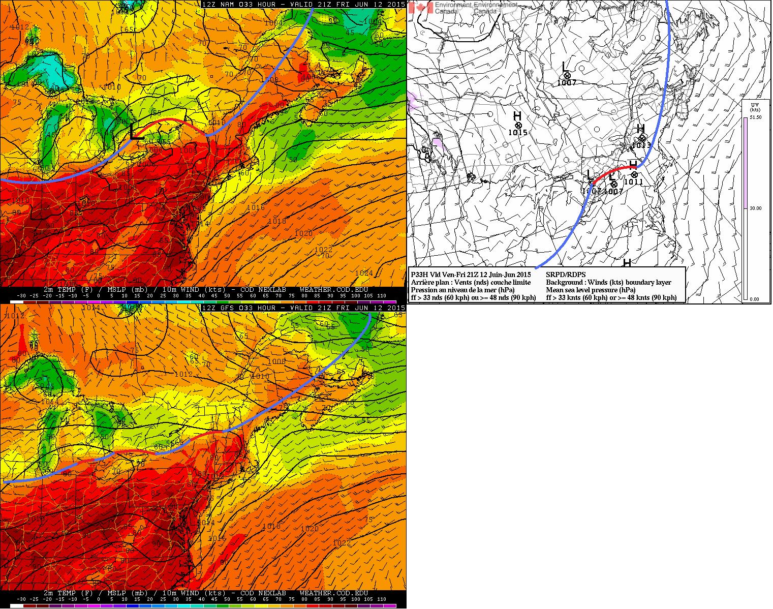
Share Article Brad Rousseau I did port early to the Twitter regarding the risk for a significant severe weather day for southern Ontario this coming Friday. Well I may have got a little ahead of myself after seeing the 06Z NAM from the morning of June 11 and I also only looked at one model. I'm not saying there isn't the risk now but the potential the potential that was being shown on the latest model runs is certainly not as high. The images shown are a 3 model comparison of the June 11 12Z (8am EDT) runs valid for 21Z (5pm EDT) for Friday June 12. Going clock wise from top left in the images are the NAM, GEM, and GFS.
Assessing the 500mb pattern all models show a broad trough swinging through southern Ontario. The main issue is going to be timing of the upper shortwave. Both the NAM and GEM agree on the timing and location of the shortawave. We can see that the GFS is a little more positively tilted with the upper trough. The tilt of the trough will be important as it will determine the strength of the large scale ascent within the warm sector and will have a direct influence on where the surface low will track. Associated with the upper trough is a 40-55 knot 500 mb jet maxima that will be pushing through southern Ontario as well. The bulk of the jet maxima will be off to the eastern parts but still ample flow over the area of interest. None the less this flow aloft is enough to provide about 30-50 knots of 0-6 km bulk shear across the region.
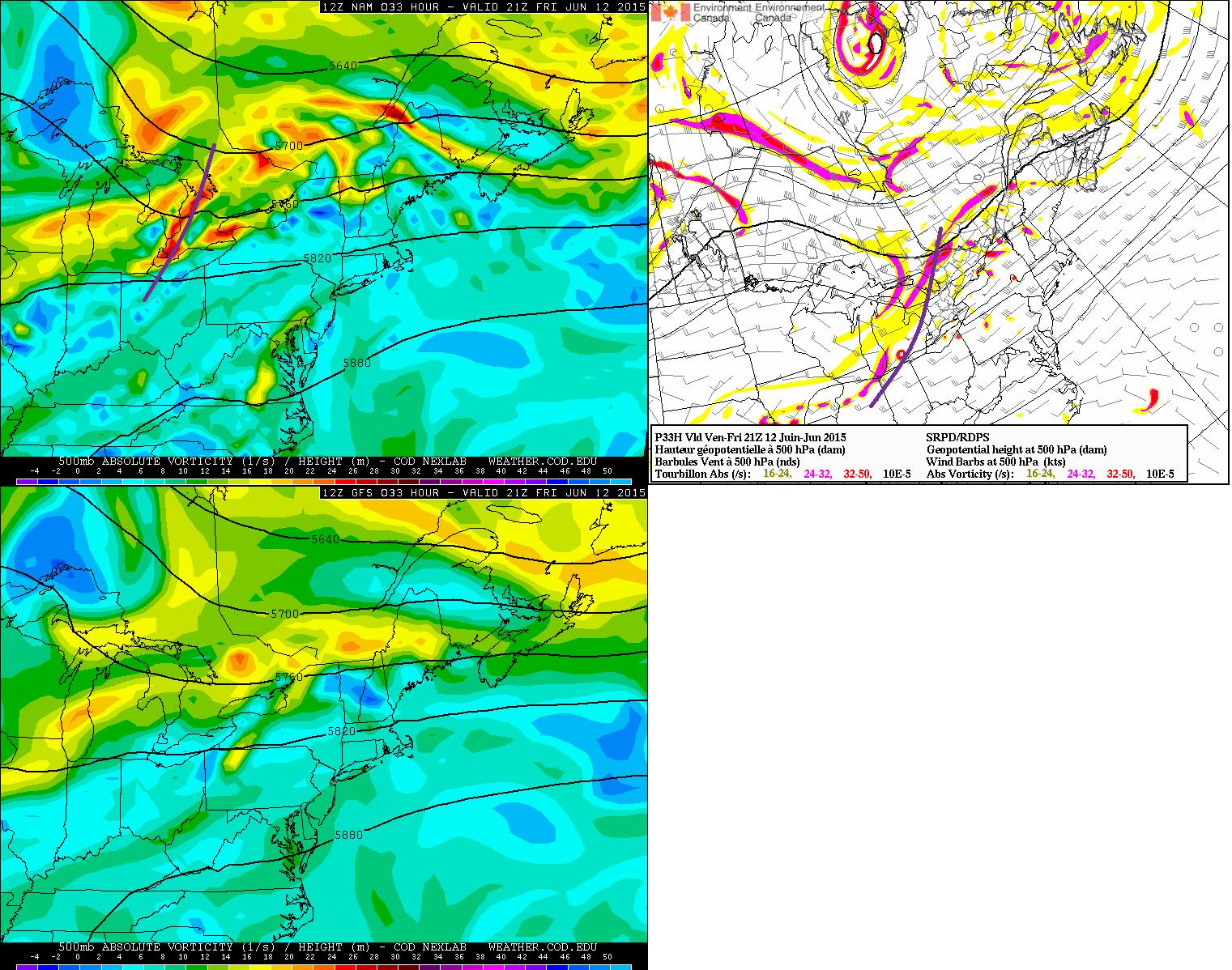
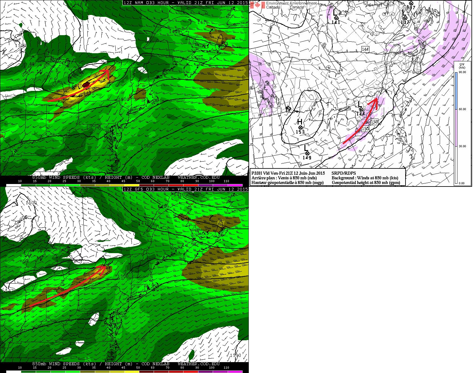
Moving down to 850mb a 35-55 knot LLJ is expected to be pushing through southwestern to eastern Ontario. Both the NAM and GEM agree with the orientation and location of the LLJ axis where the GFS is a little flatter an weaker with it. The GFS also keeps the LLJ axis mainly south of the U.S. border but brings it up into Lake Ontario. This is a result of the weaker and more positively tilted shortwave the GFS has in the 500 mb flow as shown above.
At the surface is where things between the GEM/NAM and GFS diverge a little more. We can see that both the NAM and GEM have low pushing into south central Ontario through the late afternoon. I've analyzed roughly where the frontal boundaries will be and notice that the NAM has the warm front a little farther north than the GEM. The GFS is really different with no real organized low into the province and maintains more of a stationary boundary with a few small scale vorticies along it. Again this is a direct result of the weaker and positively tilted 500 mb trough. The other thing to note on the GFS panel in the large cold pool. This is due to the fact that the GFS is maintaining the early morning convection / rain through the day. This is similar reasoning to why the GEM may have the warm front hanging back some in comparison to the NAM. Thus as the warm front and trough push in through the Friday morning hours a round of showers and elevated thunderstorms are expected. The evolution of this morning convection will determine how far north the warm front will be and thus how much moisture and instability will get into the province. The SREF maintains a lean toward the NAM/GEM solutions and I believe with the morning convection and cloud that the GEM may be onto the better solution with the warm front hanging up some.
Where the low tracks and where the warm front sets up will be important to storm mode and risk type as well. Warm fronts generate ample amounts of low level shear and helicity which forecast models may not always pick up. Below is a sounding from roughly the area just east of London where I did analyze the parcel ascent. The orange hatched area is the CAPE and the pink hatches is the CIN. From the get go I see that the CAPE is very skinny so storms may not be able to tap into 100%. There is also a pretty stout CAP as well but should be breakable with the shortwave and cold front coming through. The CAP may also help keep things a little more discrete as well only allowing the stronger updrafts to dominate but that is something we won't know until storms get going. The hodograph is a very broad looping hodograph through the 0-3 km range but is a little straight through the lowest levels. This fact with the deep layer shear available any storms that do form will likely be relatively well organized supercells. CAPE forecast from the the NAM and GEM suggest SBCAPE values near 750-2000 j/kg with the NAM staying toward the higher end of the range. How much instability builds will ultimately again be dependant on the timing of the morning convection and how much clearing there is through the day.
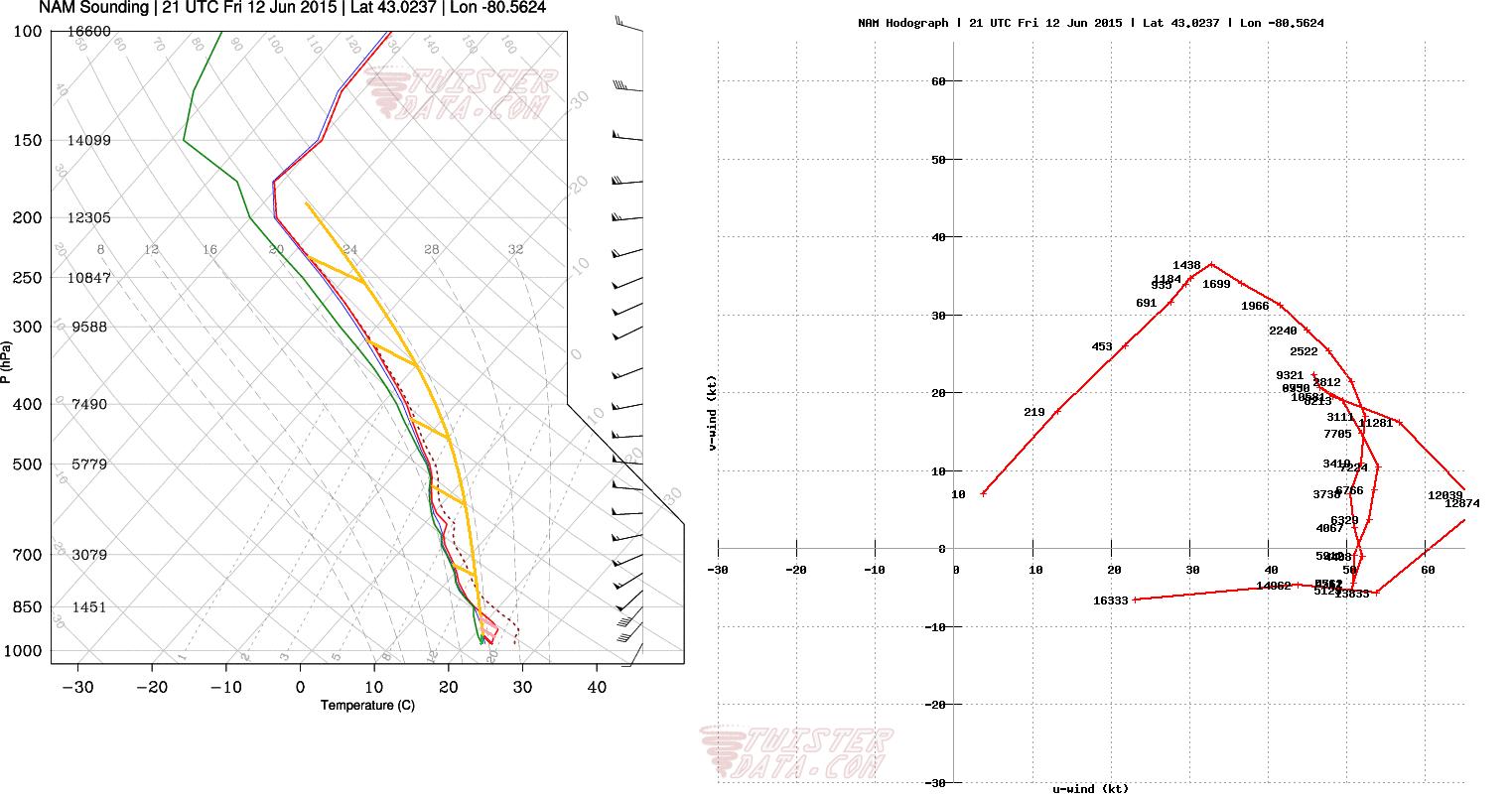 All factors assesed above and looking at some of the convective allowing models storms looks like there will be a slight chance for severe storms to develop across souther Ontario tomorrow afternoon with initation near 2-4 pm into Michigan and storms possibly coming through Ontario near the 3-5 pm range. The hodograph above is not very suggestive of it but taking more of a lean to the NAM/GEM low track and position of the warm front I think low level helicities will be a little bit more enhanced than what models are showing. So because of this I do believe supercell modes are possible with the small tornado threat. But shear vectors will lead to storm interactions and will become more linear relativelyquick. With the "skinny" CAPE the hail threat will be minimal so only small hail is likely pea to marbles maybe. In the risk map below the green area is the general T-storm risk area where some storms could become severe. The red area is where there is a higher severe risk with a very small tornado threat. Note that the tornado threat is CONDITIONAL on if the low tracks as the the GEM/NAM show and if there is sufficient instability.
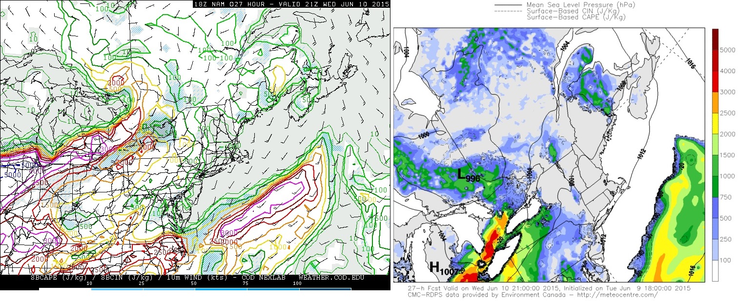
Share Article Brad Rousseau Some strong to possibly severe storms are possible for this week particularly on Wednesday around southern Ontario. I'll emphasize now there is still a good deal of uncertainty at this point in time since a broad MCS or wide spread convection is possible through the morning hours. This is important as how long the convection lingers and its exact location will alter how the days severe risk will set up. So this will only be a preliminary assessment for the time being but I have low to moderate confidence in the potential since there is generally good model agreement with the synoptic setup. I still keep it low to moderate though as again we will have to wait and see how the morning convection plays out.
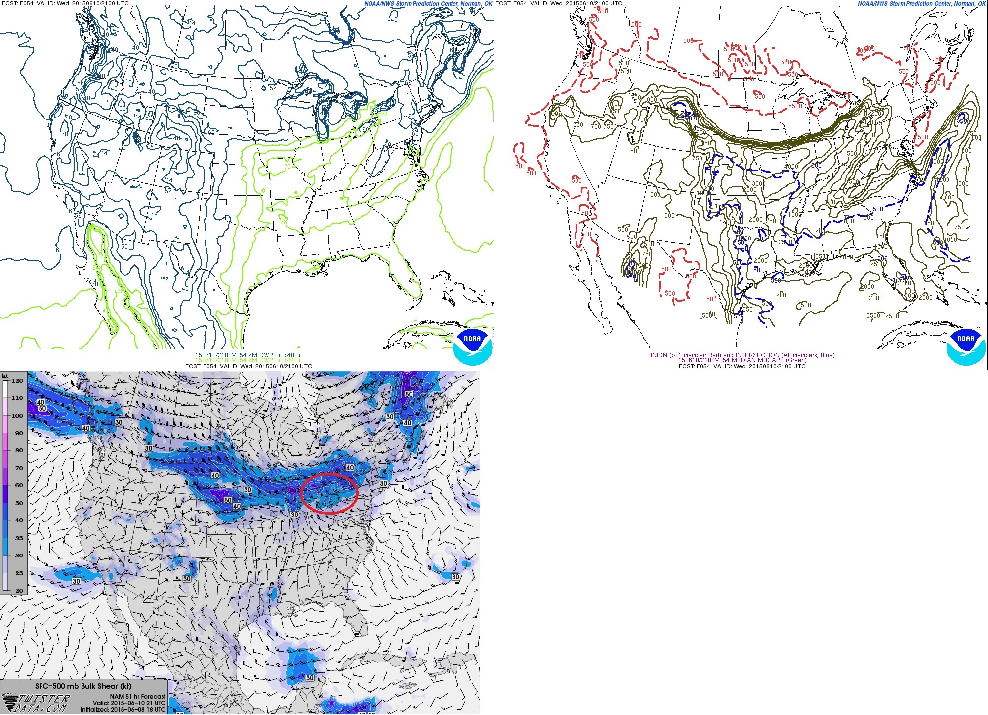
I've made a series of 4panel charts for the morning and afternoon using the 18Z NAM. I'm using these just for visuals as I discuss through the forecast. The image below is the 18Z (2 pm EDT) NAM valid for 15Z (11 am EDT) Wednesday June 10, 2015 which shows, clockwise from top left, 500 mb vorticity+geopotential heights, 500 mb winds+geopotential heights, surface temperatures / mslp / winds with the analysis done by the author, and 850 mb winds+geopotnetial heights. Looking at the vorticity and 500 mb winds we see that there is an upper level wave and 500 mb jet max pushing into north central Ontario. Down to 850 mb we see there is a strong 35-50 knot low level jet (LLJ) pushing in ahead of the upper level wave. At the surface the low is currently projected to be near the Timmins / Kapuskasing areas with the warm front pushing through south central to north central Ontario. The large scale ascent fromt the upper level wave and the low level lift from the LLJ ridinng up and over the warm front will support the widespread morning convection or MCS. Current trend with models do keep the bulk of the MCS through south central to central Ontario with some scattered thunderstorms possible through southern Ontario as the warm front pushes through. Again how this morning convection plays out will ultimately determine how the afternoon and early evening scenario sets up

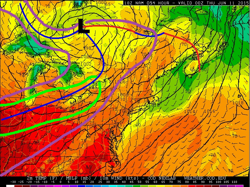
Below is the 4 panel chart made based on the same NAM run as above but is valid for 00Z June 11, 2015 or 8 pm EDT June 10, 2015. Assessing the 500 mb panels we have a shortwave trough that will be rounding the base of the 500 mb low with a 50-55 knot jet pushing into southern Ontario. Looking at the surface chart we can see that the cold front will be pushing through southern Ontario with the warm front expected to be up into southern Québec. This should allow deep moisture and high instability to push into southern Ontario. More on this below. The one issue here is with the 850 mb LLJ. We can see that the stronger southwesterly LLJ is expected to be on the U.S. side of the border except for in eastern Ontario with mostly westerly flow at 850 mb for southern Ontario. Thus the veered low level flow will not be particularly favourable for low level rotation. Should more instability be able to push into eastern Ontario, than the low level shear in place there will certainly favour better low level helicity and the potential for supercells. One other issue at this point as well is the speed of the cold front. The front is expected to push through southern Ontario relatively fast which may not allow enough heating for strong organized storms to develop or could quickly undercut any storms that do develop ahead it thus leading to be greater severe potential south of the Great Lakes into the U.S.

Below shows, counter clockwise from top left, the 15Z SREF moisture and MLCAPE valid 21Z (5 pm EDT) Wednesday June 10, 2015 and the bottom is the 18Z NAM valid 21Z (5 pm EDT) Wednesday June 10, 2015 0-6 km bulk shear. Assessing the SREF values it is projecting dew points for southern Ontario getting into the 60F to 65F range which is about 15C to 19C. With rich moisture expected the SREF is also projecting MLCAPE values of 1000-2000 j/kg. These parameters combined with 30-40 knots of 0-6 km bulk shear will certainly lead to organized severe storms. The area in red is there just to point out southern Ontario. Steep mid-level lapse rates will also lead to a fairly substantial hail threat as well again should the storms develop through the mid to late afternoon.
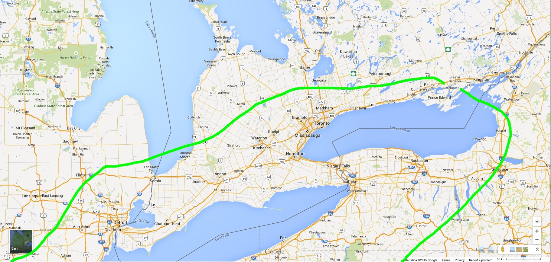
Thus putting it all together the area outlined in purple in where I think there is a general non-severe thunderstorm risk. This area also accounts for the morning convection expected as well. The green area is where I think, at this point in time, where strong to severe storms will be possible on Wednesday. The bottom map shows a zoomed in crop of the strong to severe risk area. SHOULD storms develop Wednesday afternoon in this region, shear and instability will be sufficient for organized storm clusters with the risk of moderate to large hail, frequent lightning, and strong winds. Given the veered winds I think there is a very limited tornado threat unless eastern Ontario is able to have more moisture and instability build in.
Brad Rousseau
Assessing the 12Z and 18z model runs from today a few things are starting to become a little more clear. The general synoptic setup is the same as discussed in the previous discussion so I won't touch on them to much here. I'll go more into storm modes and what the main threats could be for tomorrow. I will have to emphasize again that how the morning convection pans out will still determine how the day sets up. Some more consistency with this scenario now but it appears likely that the morning convection associated with the morning warm front passage will be able to clear out of southern Ontario to allow for sufficient day time heating. There is still high uncertainty if it will clear eastern Ontario (Peterborough / Petawawa / Ottawa) early enough to allow for sufficient heating. More on why this will be important below.
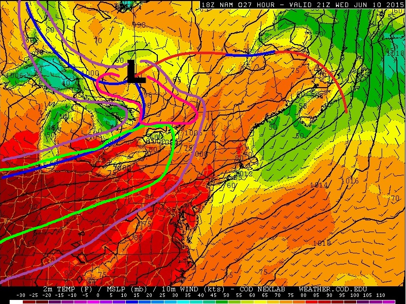
The chart below is pulled from the 18Z June 9 NAM and is valid for 21Z (5 pm EDT) Wednesday June 10. Counter clockwise from top left is 500 mb vorticity + geopotential height, 500 mb winds + geopotential height, surface temperature / winds / mslp with analysis done by the author, and 850 mb winds + geopotential heights. There are some subtle but important changes to be noted here. The 500 mb jet max has sped up some and is projected to push into south central / east central Ontario by 21Z. Looking at the vorticity field the position of the secondary shortwave has not changed a whole lot but the rough axis based on the 18Z NAM now extends from Manitoulin Island to Windsor where yesterdays had it back through Michigan. This will lead to slightly better large scale ascent and shear parameters. Looking at 850 mb we can see that the projected LLJ is expected to be a little stronger with a lightly more southerly component for eastern Ontario. At the surface the low has shifted south some with the cold front having slightly slower speed. Not shown is the moisture field but there is little change to that where the NAM / GEM / SREF are still on board with dew point in the mid to high teens and even into the low 20's for southwestern Ontario.

Another reason for slightly higher confidence now as well is the GEM is on board with the NAM in terms of the high instability through southern Ontario. Yesterdays run of the GEM did not agree with the 2000-3000 + J/kg the NAM was showing but has since com aboard for today. The SREF continues to maintain MLCAPE values into the 1000-2000 J/kg range In addition, with the 500 mb jet max arriving earlier now as mentioned above, 0-6 km bulk shear values are now projected to be up neat 35-50 knots. The combination of the instability, shear, and moisture will allow for any storms that develop to become severe in nature with a heightened threat for frequent lightning and large hail. LCL heights and wetbulb 0C mark are a little elevated so I'm not thinking we would see extremely large or damaging hail think anywhere from pea to possibly quarter sized is possible mainly for southern Ontario.
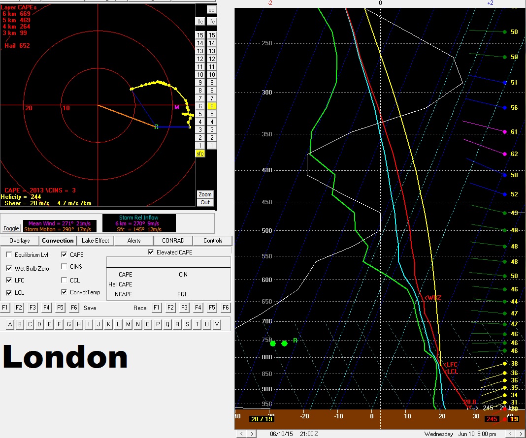
Storm modes will vary some and assessing forecast soundings will show why. Below shows the forecast sounding for 5pm in London. There is ample CAPE and shear but the hodograph shows a very broad veering pattern but very little turning within the lower levels and is kinds "flat". The 500 mb flow when compared to the surface cold front is also more parallel than perpendicular. Or in other words the shear vectors are slightly more parallel than perpendicular. This factor along with the little veering will lead to mainly splitting storms or more organized clusters which will likely evolve into a line as the cold outflow sets up. Main threats for southern Ontario would be frequent, lightning, large hail, and strong winds. Helicity values are still rather high and should there be enough interaction with lake breeze fronts than a QLCS type tornado is possible. Essentially a "spinup" along the leading edge of the line or should a good bow echo form could see a bookend vortex. Another factor for my reasoning here is the surface winds ahead of the front a terribly veered (out of the SW) which will not help with low level helicity.

 Below I have the Ottawa and Petawawa NAM forecast soundings. The Ottawa one is for 8pm EDT and the Petawawa one is for 6pm. The times differ as I want to compare the the shear and helicity values for when we have maximum CAPE or increasing CAPE. From the get go eastern Ontario is in the area of greater uncertainty since the morning convection will persist a little longer. Thus there is the risk that not enough to no instability will be able to build into this region. But should storms be bale to develop here it would appear that more organized and discrete storms could be possible. Looking at the shear vectors for the region they are much more perpendicular to the front. Thus storms will be able to keep to them selves for the most part. Low level helicity in this region is also much higher and that is evident in the much sharper and broad looping hodographs. Reason being is that the 850 mb LLJ has a more southerly component and surface winds are slightly more backed out of the SSW to slightly SSE. So this area is where there will be the slight risk of some more discrete supercell type storms SHOULD enough instability build in. Given the shear and low level helicty, should storms develop here there will be a slight tornado threat.
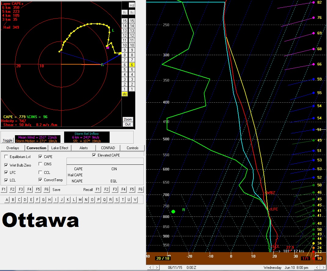
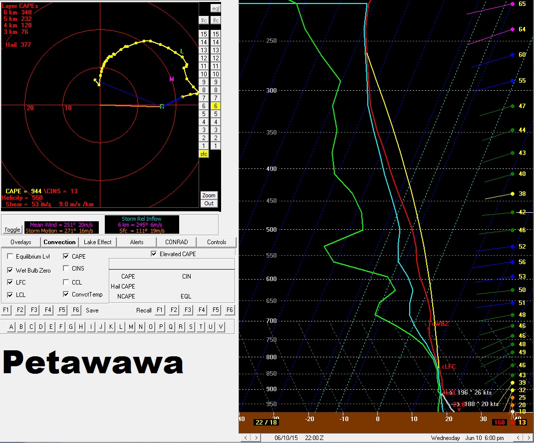
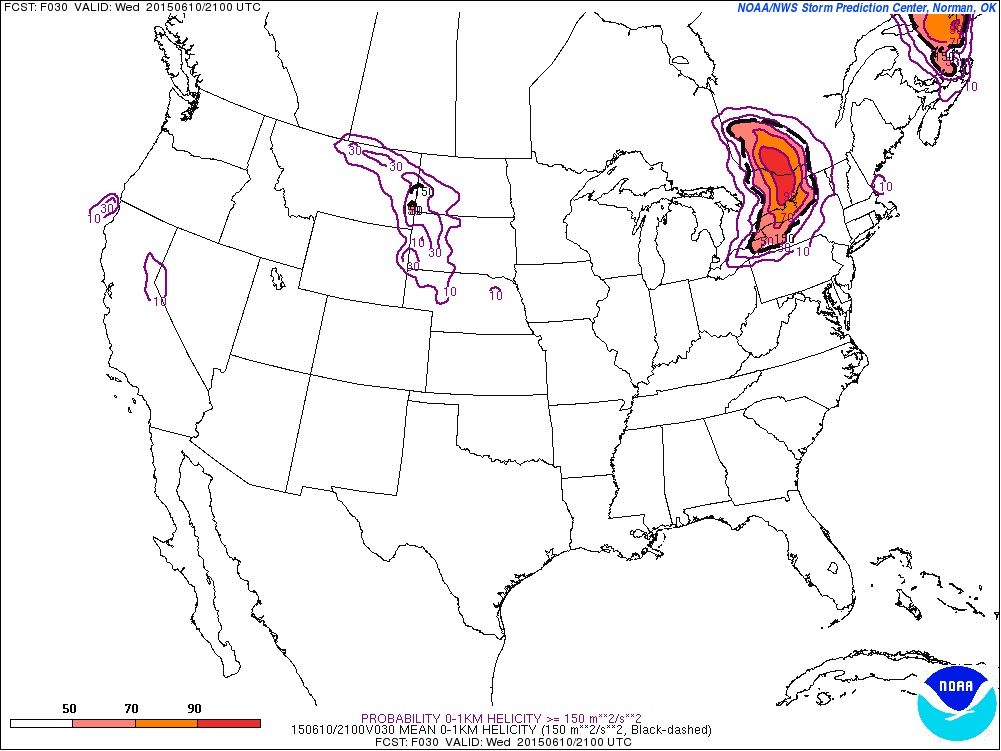
Below is the SREF's probilities of 0-1 km storm relative helicty being greater than or equal to 150 m^2/s^2. This agrees well with what the forecast soundgins and winds profiles abive show.
Below shows the risk areas with the bottom map a zoomed in look. Area in purple is a general thunderstorms risk area. The area in green is where there will be the risk for severe storms tomorrow afternoon with the main threat being frequent lightning, large hail, and strong winds. Just a very slight risk of a QLCS type tornado or landspout type tornado. The area in pink is a the area with a conditional severe risk. Should morning convection clear early enough allowing sufficient instability to build in than some discrete storms are possible with supercell modes and a slight tornado threat. NOTE the tornado threat for eastern Ontario is conditional on whether there is sufficient instability for storms to develop. Storms look to initiate along or ahead of the advancing cold front near 4-6 pm EDT.
Share Article Brad Rousseau Today (May 20, 2015) is a down day for us. Reason being is shown in the first image below which is the afternoon surface analysis. We can see that high pressure has invaded much of the central U.S. which has pushes the cold front way down into southern to southeaster Texas effectively riding the area of rich Gulf of Mexico moisture. A tentative target for today was Peco in southwestern Texas and the other was the Waco area in east central Texas. We chose to blow it off as the cold front surging southward is expected to undercut any of the convection reducing the severe threat and significantly reducing the tornado threat. So we're sitting in Amarillo right now where it is currently 12C. Not all, but much of Ontario as well as western Canada is warmer at the moment. Below I'll take a look at what our next potential chase days have in store. Quickly though it appears that the ECMWF is the model that is performing the best at this point in time. Through the medium range forecast the NAM appears to be trending toward the ECMWF pattern a little more than what the GFS is suggesting. Thus I'll use the NAM forecasts just for visualization and analysis since I cannot post the ECMWF forecasts.
This looks to be the first of the next string of chase days. At 500 mb flow returns across the souther parts of the mid-west with an upper level low centered near the California / Nevada / Arizona borders. The NAM / ECWMF a relatively similar with position and timing of the features but the ECWMF does have 35+ knots of flow into the Lubbock to Wichita Falls areas through Texas that the NAM does not show.
Moving down to 850 mb there is a persistent southerly to southeasterly low level jet that is forecast to be in place. The issue this arises is that as the upper level flow pushes in aloft large scale ascent combined with low level ascent up and over the warm front from the persistent low level jet will once again make for morning convection that will persist through the day. On the plus side the LLJ will generate ample low level shear and with the solid H5 winds in place should general good low to mid-level shear with veering hodographs.
A reflection of the potential morning and persistent convection is observed in the NAM temperature forecast through central Oklahoma, Kansas and Nebraska. The precip cooled air will also cause the surface warm front to stall out through northern and eastern Texas and through the Texas Panhandle and up into east central Colorado. The ECMWF does keep the low centered more toward the southeastern parts of Colorado near the border with New Mexico. Because of this the rich Gulf moisture is expected to get hung up through Texas and struggle to push into Colorado and Nebraska. Despite the NAM showing 55F dew points into Colorado the ECWMF keeps the dew point more toward the 50F range which is a little more realistic given the trend for the high pressure currently in place.
The lag in moisture is also reflected in the forecasted SBCAPE field as per the NAM below. There is a narrow window of 500-1000 j/kg into eastern Colorado that looks to build in between the dryline and warm front. Into Texas anywhere from 1000-3000 j/kg along and south of the warm front is possible.
The low level flow near the center of the low will make for better backed flow and low level helicity into eastern / southwestern Colorado. But the low level shear and veering winds near the warm front in north central Texas should prove equally and conducive and this setup has been the trend this May where the warm front through the Wichita Falls area has been productive. The ultimate evolution of the morning convection will also dictate whether the Colorado region can get enough daytime heating. Thus the Friday target could be from Childress to Wichita Falls and through Abilene to just east of the DFW area as outlined on the surface analysis with the southern area outlined by the green circle. The secondary target I believe will be southeastern Colorado pending moisture return and instability.
On Saturday the upper level low will drift northwards and be centered in eastern Utah near the Wyoming border. At the southern periphery of the upper low will be an H5 wind max of 25-45 knots pushing into western Texas, the Texas Panhandle, and into western Kansas. The ECMWF is a little more organize with the closed upper low and spreads the H5 jet a little farther east than what the NAM shows below.
At 850 mb a persistent southerly low level jet will be in place once again. The NAM shown below is showing a slightly veered regime but the ECWMF does keep the H8 winds more southerly to slightly east of south through the period. Again through the morning the persistent LLJ riding up and over the warm front, morning convection is expected which will keep things to the south.
Below the low analyzed in purple shows the NAM projected location and the one in black shows where the ECMWF forecasts the low to be. The frontal analysis reflects where the ECMWF has the frontal positions. With the morning convection expected again, the ECMWF again looks to be the more realistic solution. With the dryline expected to surge out through the central Texas Panhandle and the front to be draped through central Oklahoma into the eastern Texas Panhandle the environment along the I-27 corridor from Amarillo to Lubbock and into southwestern Oklahoma will be the target for now.
Share Article Brad Rousseau Today we're looking at another chance of strong thunderstorms with the slight risk of a supercell or two. Below is the 500 mb geopotnetial height along with water vapour and rap derived vorticity. There is a little speed max visible within the water vapour identified by the drier area through southern Arizona.
The other feature is the little wave that is visible on the 500 mb heights and winds which is pushing through New Mexico at this time.
At the surface, there is a stationary boundary that is pushing north with a dryline sitting through central New Mexico. Soundings and meso analysis also show a descent laps rate plume that is anticipated to push east over the Texas Panhandle along with the dryline.

Late this afternoon a meandering dryline is expected to push into the westenr Texas Panhandle. Models show various bulge regions along the dryline but below is just the 12Z NAM forecast for late this afternoon.
Mid level shear is relatively weak but low level shear is suffucient particulary late day as the 850 mb LLJ is set to pick up to 25-40 kts. So the idea for today is hopefully the upper level wave and 500mb speed max, all be it weak, will meet over the southern Texas Panhandle near the Lubbock region late day which will aid in large scale ascent with the dryline helping to focus initiation. With SBCAPE expected to be near 2500-4000 j/kg vertical velocities within any storms should be able to make use of any low level shear available for some rotating storms.
Don't want to venture to far south as we need to get north for Friday near the central parst of the KS/NE border into south central NE.
Share Article