Comments Off |  Share Article
Share Article 


Brad Rousseau Some strong to possibly severe storms are possible for this week particularly on Wednesday around southern Ontario. I'll emphasize now there is still a good deal of uncertainty at this point in time since a broad MCS or wide spread convection is possible through the morning hours. This is important as how long the convection lingers and its exact location will alter how the days severe risk will set up. So this will only be a preliminary assessment for the time being but I have low to moderate confidence in the potential since there is generally good model agreement with the synoptic setup. I still keep it low to moderate though as again we will have to wait and see how the morning convection plays out.
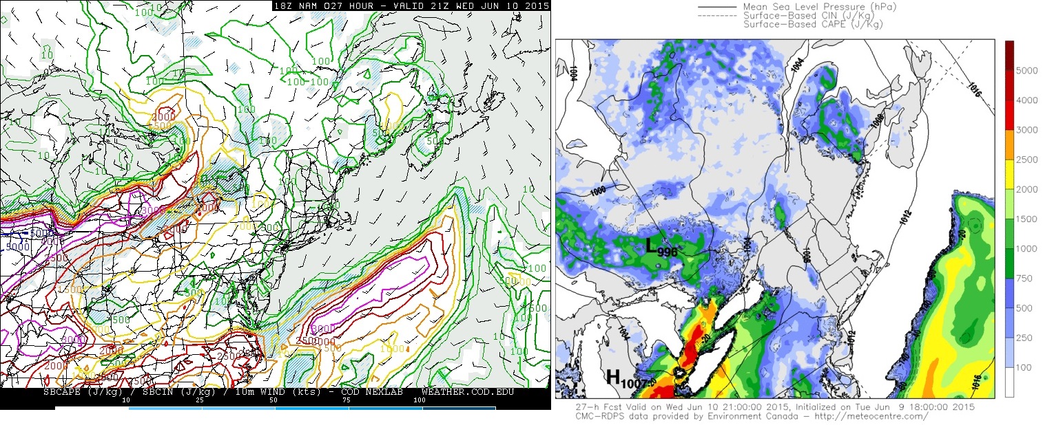
I've made a series of 4panel charts for the morning and afternoon using the 18Z NAM. I'm using these just for visuals as I discuss through the forecast. The image below is the 18Z (2 pm EDT) NAM valid for 15Z (11 am EDT) Wednesday June 10, 2015 which shows, clockwise from top left, 500 mb vorticity+geopotential heights, 500 mb winds+geopotential heights, surface temperatures / mslp / winds with the analysis done by the author, and 850 mb winds+geopotnetial heights. Looking at the vorticity and 500 mb winds we see that there is an upper level wave and 500 mb jet max pushing into north central Ontario. Down to 850 mb we see there is a strong 35-50 knot low level jet (LLJ) pushing in ahead of the upper level wave. At the surface the low is currently projected to be near the Timmins / Kapuskasing areas with the warm front pushing through south central to north central Ontario. The large scale ascent fromt the upper level wave and the low level lift from the LLJ ridinng up and over the warm front will support the widespread morning convection or MCS. Current trend with models do keep the bulk of the MCS through south central to central Ontario with some scattered thunderstorms possible through southern Ontario as the warm front pushes through. Again how this morning convection plays out will ultimately determine how the afternoon and early evening scenario sets up

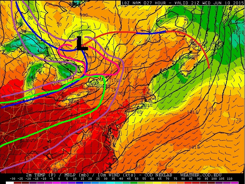
Below is the 4 panel chart made based on the same NAM run as above but is valid for 00Z June 11, 2015 or 8 pm EDT June 10, 2015. Assessing the 500 mb panels we have a shortwave trough that will be rounding the base of the 500 mb low with a 50-55 knot jet pushing into southern Ontario. Looking at the surface chart we can see that the cold front will be pushing through southern Ontario with the warm front expected to be up into southern Québec. This should allow deep moisture and high instability to push into southern Ontario. More on this below. The one issue here is with the 850 mb LLJ. We can see that the stronger southwesterly LLJ is expected to be on the U.S. side of the border except for in eastern Ontario with mostly westerly flow at 850 mb for southern Ontario. Thus the veered low level flow will not be particularly favourable for low level rotation. Should more instability be able to push into eastern Ontario, than the low level shear in place there will certainly favour better low level helicity and the potential for supercells. One other issue at this point as well is the speed of the cold front. The front is expected to push through southern Ontario relatively fast which may not allow enough heating for strong organized storms to develop or could quickly undercut any storms that do develop ahead it thus leading to be greater severe potential south of the Great Lakes into the U.S.

Below shows, counter clockwise from top left, the 15Z SREF moisture and MLCAPE valid 21Z (5 pm EDT) Wednesday June 10, 2015 and the bottom is the 18Z NAM valid 21Z (5 pm EDT) Wednesday June 10, 2015 0-6 km bulk shear. Assessing the SREF values it is projecting dew points for southern Ontario getting into the 60F to 65F range which is about 15C to 19C. With rich moisture expected the SREF is also projecting MLCAPE values of 1000-2000 j/kg. These parameters combined with 30-40 knots of 0-6 km bulk shear will certainly lead to organized severe storms. The area in red is there just to point out southern Ontario. Steep mid-level lapse rates will also lead to a fairly substantial hail threat as well again should the storms develop through the mid to late afternoon.
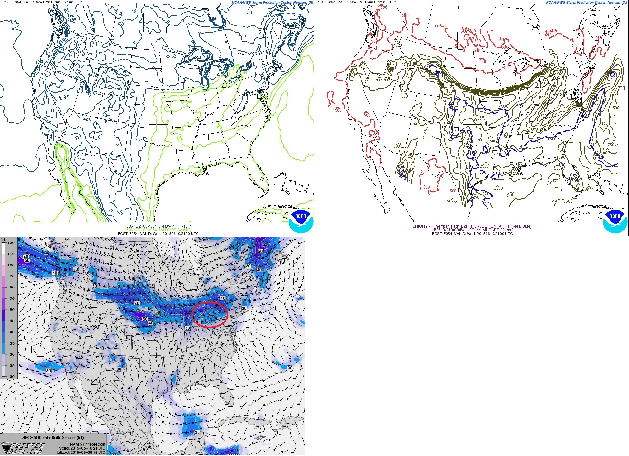
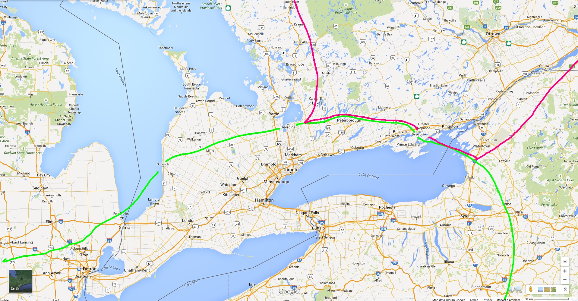
Thus putting it all together the area outlined in purple in where I think there is a general non-severe thunderstorm risk. This area also accounts for the morning convection expected as well. The green area is where I think, at this point in time, where strong to severe storms will be possible on Wednesday. The bottom map shows a zoomed in crop of the strong to severe risk area. SHOULD storms develop Wednesday afternoon in this region, shear and instability will be sufficient for organized storm clusters with the risk of moderate to large hail, frequent lightning, and strong winds. Given the veered winds I think there is a very limited tornado threat unless eastern Ontario is able to have more moisture and instability build in.
Brad Rousseau
Assessing the 12Z and 18z model runs from today a few things are starting to become a little more clear. The general synoptic setup is the same as discussed in the previous discussion so I won't touch on them to much here. I'll go more into storm modes and what the main threats could be for tomorrow. I will have to emphasize again that how the morning convection pans out will still determine how the day sets up. Some more consistency with this scenario now but it appears likely that the morning convection associated with the morning warm front passage will be able to clear out of southern Ontario to allow for sufficient day time heating. There is still high uncertainty if it will clear eastern Ontario (Peterborough / Petawawa / Ottawa) early enough to allow for sufficient heating. More on why this will be important below.
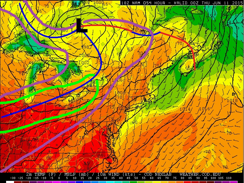
The chart below is pulled from the 18Z June 9 NAM and is valid for 21Z (5 pm EDT) Wednesday June 10. Counter clockwise from top left is 500 mb vorticity + geopotential height, 500 mb winds + geopotential height, surface temperature / winds / mslp with analysis done by the author, and 850 mb winds + geopotential heights. There are some subtle but important changes to be noted here. The 500 mb jet max has sped up some and is projected to push into south central / east central Ontario by 21Z. Looking at the vorticity field the position of the secondary shortwave has not changed a whole lot but the rough axis based on the 18Z NAM now extends from Manitoulin Island to Windsor where yesterdays had it back through Michigan. This will lead to slightly better large scale ascent and shear parameters. Looking at 850 mb we can see that the projected LLJ is expected to be a little stronger with a lightly more southerly component for eastern Ontario. At the surface the low has shifted south some with the cold front having slightly slower speed. Not shown is the moisture field but there is little change to that where the NAM / GEM / SREF are still on board with dew point in the mid to high teens and even into the low 20's for southwestern Ontario.

Another reason for slightly higher confidence now as well is the GEM is on board with the NAM in terms of the high instability through southern Ontario. Yesterdays run of the GEM did not agree with the 2000-3000 + J/kg the NAM was showing but has since com aboard for today. The SREF continues to maintain MLCAPE values into the 1000-2000 J/kg range In addition, with the 500 mb jet max arriving earlier now as mentioned above, 0-6 km bulk shear values are now projected to be up neat 35-50 knots. The combination of the instability, shear, and moisture will allow for any storms that develop to become severe in nature with a heightened threat for frequent lightning and large hail. LCL heights and wetbulb 0C mark are a little elevated so I'm not thinking we would see extremely large or damaging hail think anywhere from pea to possibly quarter sized is possible mainly for southern Ontario.
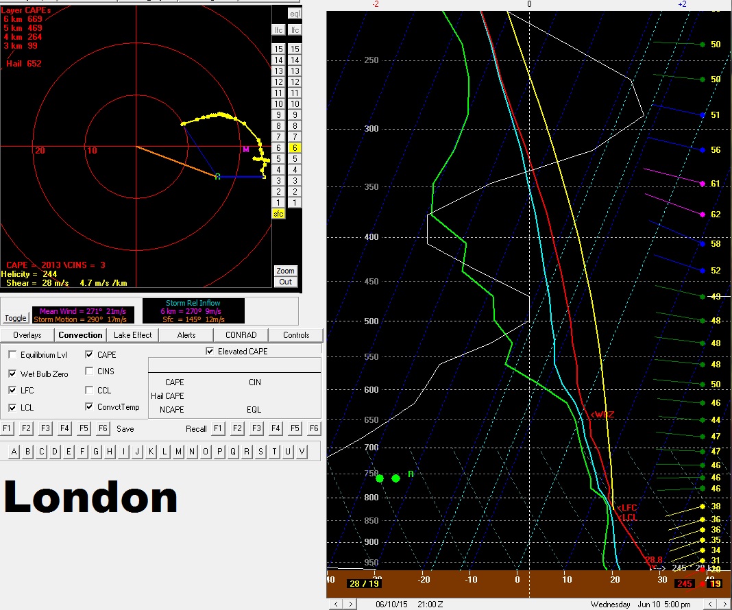
Storm modes will vary some and assessing forecast soundings will show why. Below shows the forecast sounding for 5pm in London. There is ample CAPE and shear but the hodograph shows a very broad veering pattern but very little turning within the lower levels and is kinds "flat". The 500 mb flow when compared to the surface cold front is also more parallel than perpendicular. Or in other words the shear vectors are slightly more parallel than perpendicular. This factor along with the little veering will lead to mainly splitting storms or more organized clusters which will likely evolve into a line as the cold outflow sets up. Main threats for southern Ontario would be frequent, lightning, large hail, and strong winds. Helicity values are still rather high and should there be enough interaction with lake breeze fronts than a QLCS type tornado is possible. Essentially a "spinup" along the leading edge of the line or should a good bow echo form could see a bookend vortex. Another factor for my reasoning here is the surface winds ahead of the front a terribly veered (out of the SW) which will not help with low level helicity.

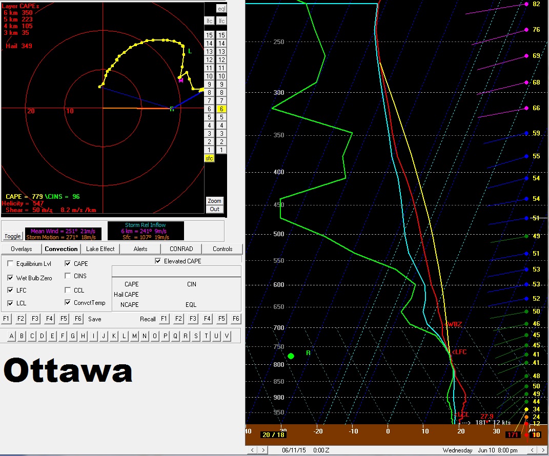
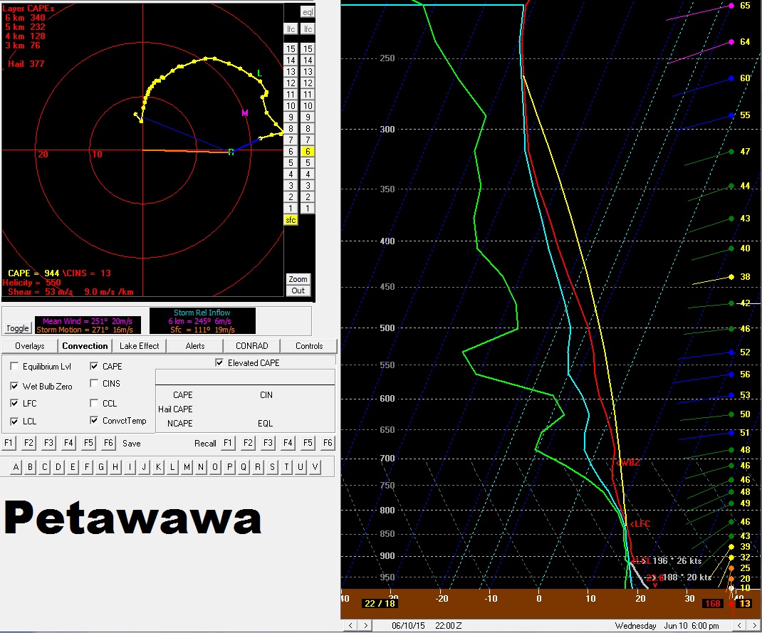
 Below I have the Ottawa and Petawawa NAM forecast soundings. The Ottawa one is for 8pm EDT and the Petawawa one is for 6pm. The times differ as I want to compare the the shear and helicity values for when we have maximum CAPE or increasing CAPE. From the get go eastern Ontario is in the area of greater uncertainty since the morning convection will persist a little longer. Thus there is the risk that not enough to no instability will be able to build into this region. But should storms be bale to develop here it would appear that more organized and discrete storms could be possible. Looking at the shear vectors for the region they are much more perpendicular to the front. Thus storms will be able to keep to them selves for the most part. Low level helicity in this region is also much higher and that is evident in the much sharper and broad looping hodographs. Reason being is that the 850 mb LLJ has a more southerly component and surface winds are slightly more backed out of the SSW to slightly SSE. So this area is where there will be the slight risk of some more discrete supercell type storms SHOULD enough instability build in. Given the shear and low level helicty, should storms develop here there will be a slight tornado threat.
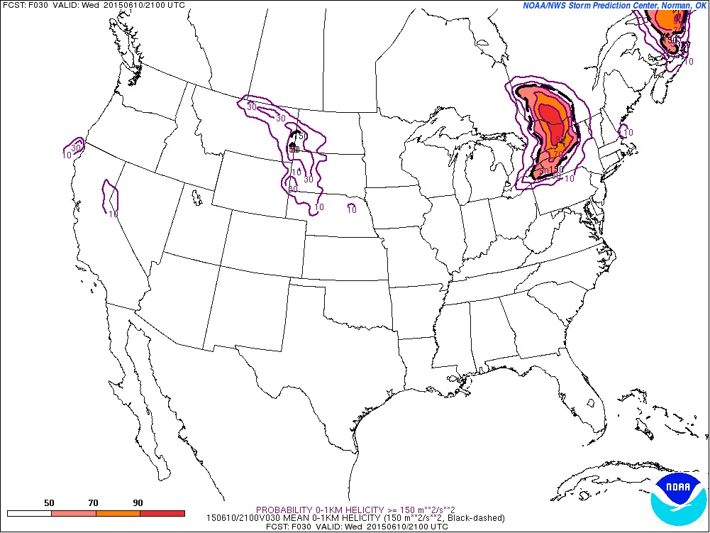
Below is the SREF's probilities of 0-1 km storm relative helicty being greater than or equal to 150 m^2/s^2. This agrees well with what the forecast soundgins and winds profiles abive show.
Below shows the risk areas with the bottom map a zoomed in look. Area in purple is a general thunderstorms risk area. The area in green is where there will be the risk for severe storms tomorrow afternoon with the main threat being frequent lightning, large hail, and strong winds. Just a very slight risk of a QLCS type tornado or landspout type tornado. The area in pink is a the area with a conditional severe risk. Should morning convection clear early enough allowing sufficient instability to build in than some discrete storms are possible with supercell modes and a slight tornado threat. NOTE the tornado threat for eastern Ontario is conditional on whether there is sufficient instability for storms to develop. Storms look to initiate along or ahead of the advancing cold front near 4-6 pm EDT.
Share Article