Comments Off |  Share Article
Share Article 


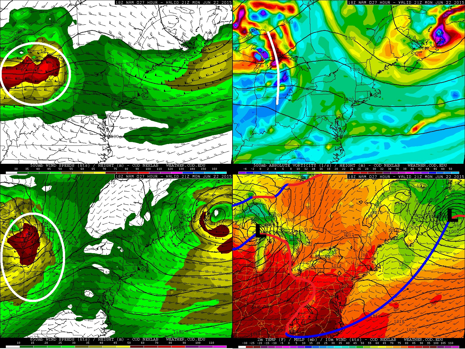
Brad Rousseau There will be the risk for strong thunderstorms across most of southern Ontario for Monday night into Tuesday morning. But I cannot completely rule out the risk for mid to late Monday afternoon for southwestern Ontario. Below is a 4 panel chart where I am showing the June 21 18Z (2pm EDT) NAM which is valid for 21Z (5pm EDT) Monday June 22. Note that I'm merely using the NAM for some visual references when discussing the forecast but will note that there is good model agreement among the NAM/GEM/GFS/ECMWF/SREF with the synoptic scale features. In terms of mesoscale features (i.e. outflow boundaries, confluence regions, lake breeze fronts) those are yet to be determined and will play a key role in the severe weather risk but for now I'll give a broad overview. Back to the 4 panel image from top left going clockwise is 500 mb winds and geopotential heights, 500 mb absolute vorticity and geopotential heights, surface temperature/wind/mslp with analysis done by myself, and 850 mb winds and geopotential heights. We can see we have a 70-90 knots 500 mb jet pushing into northern Michigan over Lake Huron with a 55-70 knot flow through central / southern Michigan and nosing into southwestern Ontario. Looking at the 500 mb vorticity there is a shortwave expected to track through central Michigan near the 5pm EDT time frame. The shortwave is more potent into the Superior East region of Ontario but does exhibit subtle trough through south central Michigan. At the surface the low is expected to be somewhere along the northwestern shores of lake Michigan near the WI / MI border with the warm front drapped through northern / eastern MI into southwestern Ontario. Although precipitation models are not indicating much of a risk at this time, I believe the large scale ascent from the upper shortwave in combination with the advancing warm front may provide enough lift to give the slight risk of some thunderstorms developing through central MI which could push into southwestern Ontario through the late afternoon.
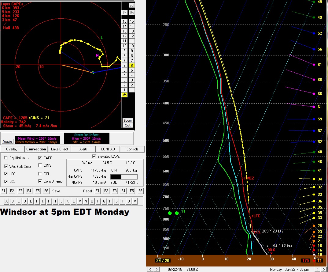
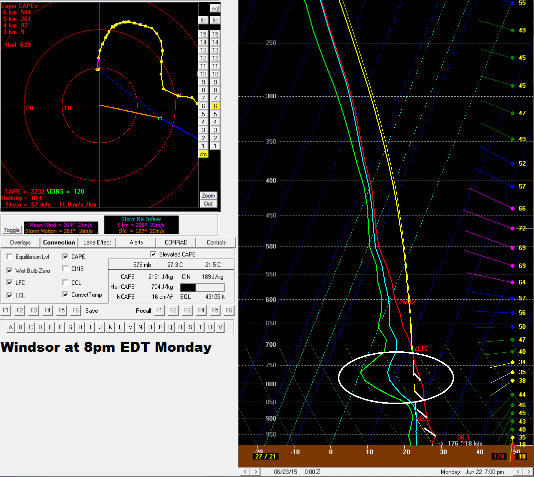
Below are the 5pm and 8pm forecast soundings for the Windsor area for June 22 based off the 12Z NAM from June 21. At 5pm the environment appears to be freely convective with a nice veering wind profile and a large looping hodograph which will be favourable for well organized supercells. By 8pm we can see that there is some higher CIN (Convective Inhibition) building back in (white hatched area) with some weak subsidence between 850-750mb as outlined by the circled area. This leads me to believe that the window of opportunity for mid to late afternoon storms will be near 4-8pm which lines up well with the passage of the upper shortwave and advancing warm front. So given MLCAPE values near 1000-2000 j/kg for southwestern Ontario and 2000-4000 for j/kg for MI, 0-6 km bulk shear near 45-70 knots, 40-50 knots southerly 850 mb LLJ, 200-450 m^2/s^2, and veering wind profiles with large looping hodographs, should any storms develop in this environment discrete supercells will certainly be the primary storm mode with the risk for a few tornadoes. NOTE that I'm not saying this will be the case but that there is just a very slight chance that storms could initiate in this environment given the parameters discussed here. The main risk for Ontario will be limited to the extreme southwest portion which will be Sarnia - Lambton as well as Windsor-Essex-Chatham-Kent regions.
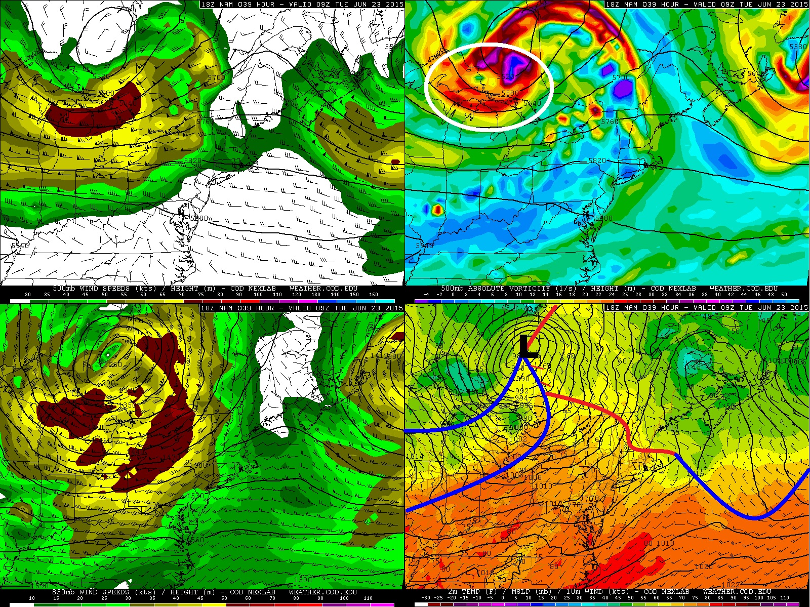
4 panel chart below is the same as the one above but valid for 5am Tuesday morning. It is during the overnight through early Tuesday morning where there is a more certain risk of thunderstorms across most of southern Ontario. Aloft we have the 65-75 knot 500 mb jet overtaking most of central, southern, and eastern Ontario with the primary short wave advacing through central Ontario along with an 850 mb southwesterly to westerly 45-75 knot LLJ. At the surface the low is expected to be within northeastern Ontario north of the Timmins area with the lead cold front surging through central to southern Ontario. There remains some uncertainty with how the cold front will behave through MI as shear vectors do suggest the possibility of more discrete supercells. But current forecast trend looks to favour more linear mode with the advancing cold front. That being said should discrete supercells develop throuh WI / MI it is expected that they will transitions into linear segments or even a large squall line. Regardless it is likely for Ontario mainly a linear mode is expected which will push through the province starting about 10 pm through to Tuesday morning.
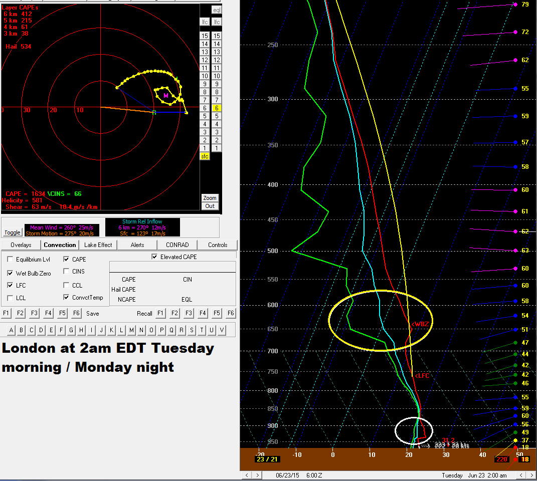
Below is a forecast sounding from the June 21 12Z NAM which is valid for 2am EDT Tuesday morning (Monday night). A couple issues I'm seeing is the low level inversion as indicated by the white circled area and the other is the subsidence layer aloft as outlined by the yellow circle. These features do get washed out through to the 9Z (5am EDT) sounding however. With 40-60 knots of 0-6 km shear and MLCAPE values near 1000-3000 j/kg a strong squall line looks likely for the province with the potential for strong and potentially damaging winds, heavy and possibly significant rain with the risk for some localized flooding, frequent lighting, and small hail. I see the word derecho being thrown around with this event but I hold my reservation on that for the time being given the sounding issues, but with the potent 850 mb LLJ certainly strong and potentially damaging wind gusts are possible.
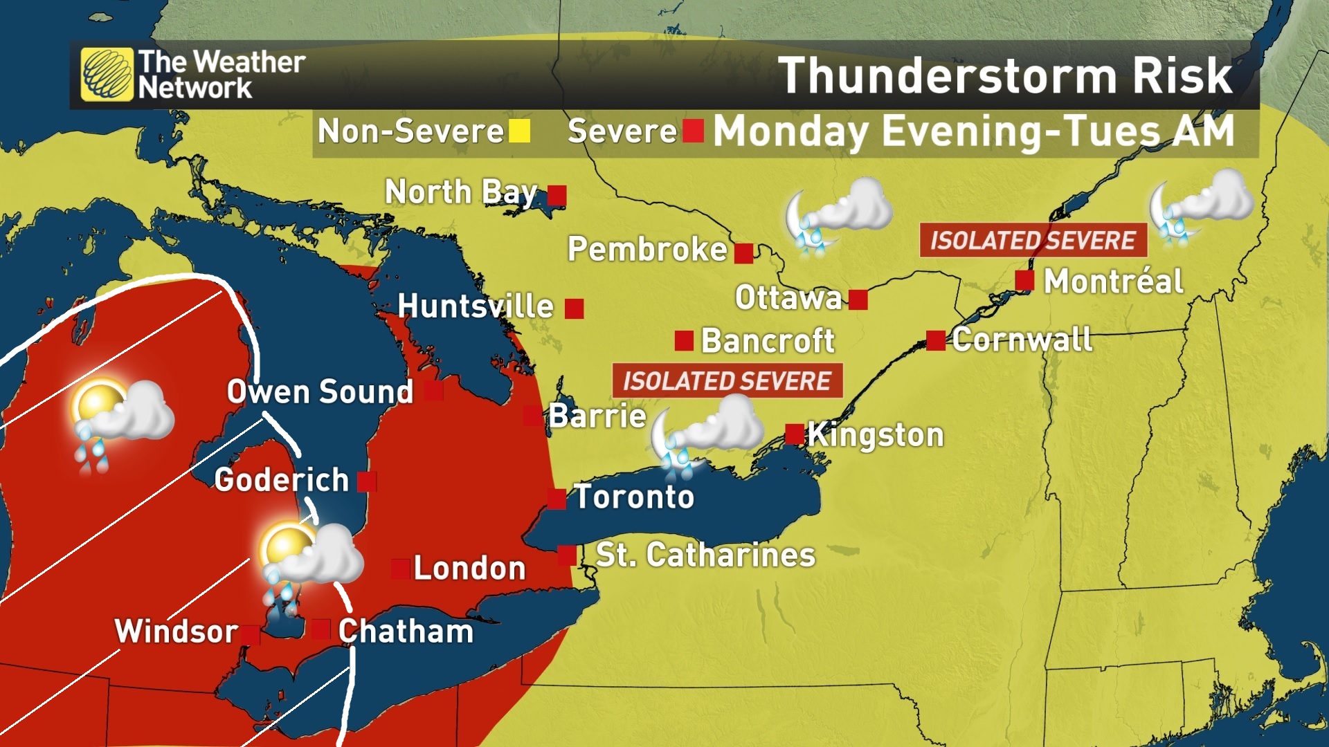
Below is the current risk map produced by The Weather Network. The area in red outlines where the greatest severe risk will be for Monday evening through to Tuesday morning with the yellow area only having a slight risk of a severe storms or two. The white hatched area I added outlines the late afternoon / early evening risk of a couple discrete supercells with a slight tornado threat SHOULD the warm front trigger any storms. NOTE THIS RISK FOR THE WHITE HATCHED AREA IS ONLY A SMALL CHANCE AND THE TORNADO THREAT DEPENDS ON WHETHER OR NOT ANY STORMS CAN INITIATED ON THE WARM FRONT WITH THE LEAD SHORTWAVE THROUGH THE AFTERNOON. THE MORE CERTAIN RISK IS THE MONDAY EVENING/OVERNIGHT POTENTIAL SQUALL LINE.
Share Article