


May 16 - Chase Day, Morning Update
***Update***
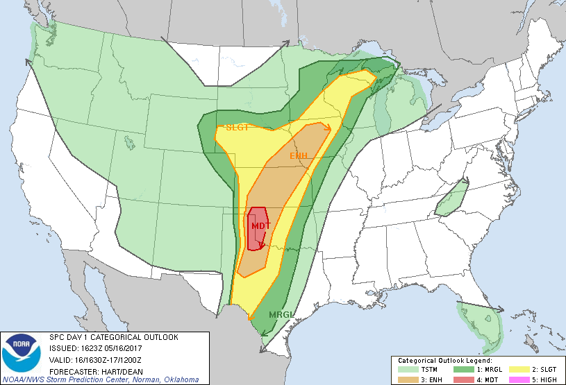
The NWS SPC has upgraded to a MODERATE for today with a 15% risk for tornadoes.
-------------------------------------------------------------------
Hello from the road...
Just left Woodward, Oklahoma on our way south toward the I-40 corridor. We plan on heading that way toward the Texas/Oklahoma border and re-assess our target for the day.
As for today's forecast:
Strong upper level winds and low level shear with plenty of energy to be had is the recipe for today in western Oklahoma and the eastern Texas Panhandle. There is a long meandering dryline that will be the focus point for initiation today but the trick is to pick the right spot along the dryline. The strongest forcing along the dryline is progged to be in the eastern Texas Pandhandle and western to southwestern Oklahoma. This is where we believe, based on forecast soundings and hodographs, some discrete supercells will form later today.
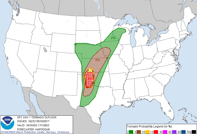
 SPC Day 1 tornado probability for this afternoon and evening (valid for May 16, 2017).
There is some concerns due to the wind profiles because we are noticing a veer-back-veer profile in the winds which often times can inhibit tornado genesis or lessen the risk for tornadoes on a day like today. Nevertheless, this concerning profile pattern looks to be above 3 km which shouldn't impact the surface-based storms too much.
The biggest risks today will be very large hail, strong winds, lightning of course, and the possibility of tornadoes.
If you would like to follow along with us, again, we'll be on Twitter, but if you use SpotterNetwork, you can look for "Brad Rousseau".
 Dayna Vettese
May 15 - Travel Day 2 & First Chase Day
Hello from Woodward, Oklahoma!
A lot of driving again today, but, what else is new when you're storm chasing. We started the morning off in Higginsville, Missouri then met up with Scott and Dave in Emporia, Kansas. From there we started making our way southwest into southwest Kansas. The day had marginal risks but was worth the chase.
We met up with storms in the Guymon, Oklahoma area (in the Oklahoma Panhandle) where we stayed and watched them for a bit. They were all very high based which was the worry for today. A storm down near Stinnett, Texas was starting to look more promising so we started south toward Spearman, Texas to meet up with the storm. We got there and again, it looked very high based so we hung around for a while and watched the beautiful lightning display for a while.
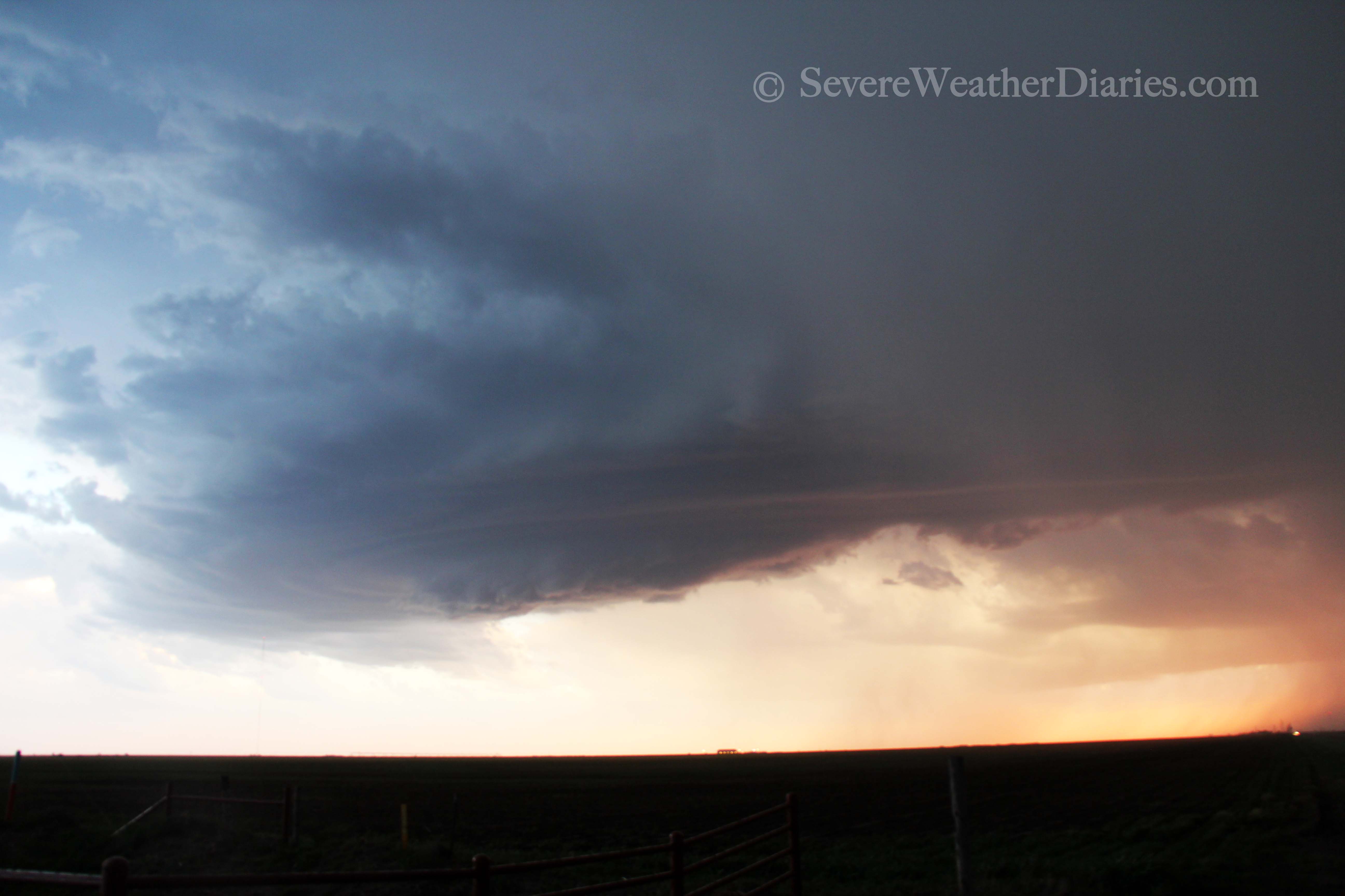 Supercell at sunset south of Spearman, Texas on May 15, 2017.
The sun began to set and the storm was dying so we started east to get our hotel for the night. As we did so, Brad noticed a lowering on the storm so we pulled over to watch. We were quite far by this point but sure enough, it developed a very distinct funnel. We were too far away to tell if it touched down but chasers who were closer only reported the funnel. We can thank the low level jet kicking in for that brief funnel cloud.
We're now spending the night in Woodward, Oklahoma getting ready for a decent chase day tomorrow. The Storm Prediction Center has already issued an ENHANCED RISK for tomorrow and everything is looking favourable for severe storms.
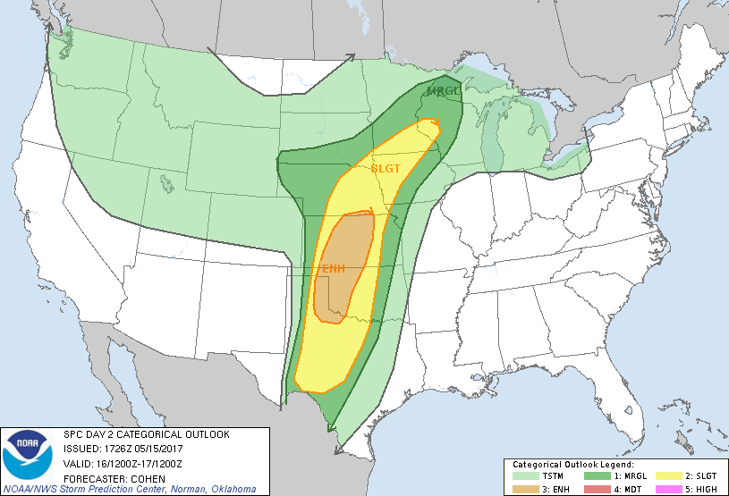 SPC Day 2 categorical outlook is a Slight Risk (valid for May 16, 2017).
We don't anticipate having to travel too far from this area. Any issues for storms tomorrow just include some capping concerns but other than that, the setup looks to be in our favour. Being close to the potential target area tomorrow will allow for us to catch up on some sleep.
May 14 - Travel Day 1
Hello from Higginsville, Missouri!
Looong travel day for us. We left home at about 7:30am and put in 17 hours worth of driving, or 1500 km (about 930 miles).
We ran into a bit of a delay at the border because we were picked for a vehicle search but after finding only nerd gadgets, snacks, and a sudoku book, they sent us on our way. We activated our internet hot spot without issue near Toledo, Ohio but then noticed a small issue... the hot spot would not hold a charge! After doing a bit of trouble shooting it seems that the hot spot would get a charge, stay on for a bit, then kick off and lose all of its juice. I looked up a battery store in Indianapolis and we saw we could make it there with an hour before closing and it was pretty darn likely that they would not have this battery (since it's a pretty old model hot spot). The store had one left, one left! It seems to be working fine and charging so here's hoping that stays that way... Our other options are very limited.
Tomorrow we have our eyes set on southwestern Kansas. We're taking a look at models now and have been periodically throughout the day and have been favouring that area. A bit of a dryline setup in the area should give us that lift we need, moisture is a small concern though current observations are favourable. The LCL's (cloud bases if you will) are progged to be on the high side tomorrow so tornado threat is low but non-zero so off we'll go!
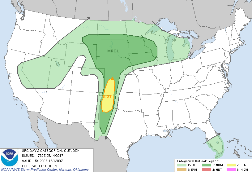 SPC Day 2 categorical outlook is a Slight Risk (valid for May 15, 2017).
We'll get an early start tomorrow and meet up with Scott and Dave along the way as they're already a few hours ahead in travel in Kansas already. If you want to follow along, we'll both be posted to Twitter on occassion: Dayna and Brad.
May 12 - Getting Ready to Go
It's been a while... Too long! We didn't do a big Tornado Alley trip last year (which translated to us missing some pretty incredible tornadoes) but sometimes life works out that way. We'll be heading down very soon for a trip this year. It'll be myself and Brad (his blog here) for the duration of our trip and, of course, meeting up with our chase friends. The plan is to leave Sunday morning from Toronto and make it to somewhere west of St. Louis, MO. We'd like to get into position to chase on Monday as things look favourable for some good storms. This week bodes well for some good chase days based on the models so here's hoping to an active week. We're currently busy packing and getting everything ready and will update once we're on the road.