


Entries by Dayna Vettese (28)
Fifth Chase Day - Sweltering, Baseball Hail and Devastation
May 22 Chase Day: Today was quite the interesting day. We started off in Ardmore, Oklahoma this morning. After looking at the models we decided staying around the Ardmore area would be the most advantageous for us. There was storm potential stretching across most of the mid-United States. We could see a lot of storm chasers were targeting Missouri and Kansas. We decided to stay in Oklahoma for two reasons: 1) It would put us in better position for tomorrow's target and 2) The way the weather was setting up, the storms in Missouri and Kansas looked like they would be high precipitation supercells which means non-visible tornadoes and very dangerous conditions.
We stuck around Ardmore for most of the afternoon in the sweltering heat. It was 33°C with a dew point of 25°C. That's roughly a humidex of 45°C! Storms began to go up late in the afternoon. We chased down towards the Red River area but the storms began to disorganize themselves by the time we got there and never really produced anything but big hail. We just missed the core of the storm and went to take a look at the hailstones. They were baseball size by the time we got there which means they had melted quite a bit in the 30+°C heat. Needless to say there were a lot of broken windshields. I will be uploading pictures of the hail to my photo gallery.
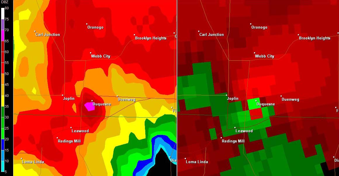
At this point we started hearing the devastating news about Joplin, Missouri. A rain-wrapped tornado tore through Joplin and destroyed parts of the city. Based on damage pictures and reports it looks like a war zone. A couple of fellow chasers I've met are there helping right now. The hospital itself in Joplin has been damaged as well. Absolute devastation. As a storm chaser we love to see tornadoes but its best when the tornado occurs in the middle of a field and poses no threat to anyone. Here is a screen capture of the radar over Joplin:
The main issue with this tornado is no one could see it coming. This tornado was completely rain-wrapped which means to the average person it would just look like a lot of rain then all of a sudden tornadic winds. Here is a panoramic view of the devastation: Joplin, MO Panorama Damage
We went after a couple of more cells but then decided to call it quits for the night. We made our way to Norman, Oklahoma where we're spending the night. Looks like storm activity will be in this area tomorrow so we'll hold tight.
I've been trying to upload pictures and videos but there's a couple of issues. The first issue is we haven't really had a "down" day where there's no storms so we've had little time to process our pictures and edit videos. Secondly, the internet at these hotels is horrid. Very slow upload/download speeds. I'm attempted to upload pictures and video tonight but it may not be finished in time.
 Dayna Vettese
Fourth Chase Day - Tornado, Indecision and BBQ
May 21 Chase Day: Sorry for the delay in updates. The last two days we've had little to no internet connection at the hotels. Finally got a little bit of a good connection this morning. I'm currently in Ardmore, Oklahoma and yesterday (fourth chase day, May 21) we saw our first tornado of 2011!
We started the day off in Enid, Oklahoma and if you ever decide to come storm chasing and decide to stay in Enid: do not stay at the Days Inn on America's Best Value Inn. They are awful hotels, dirty, stinky and on the wrong side of town. The Super 8 and other hotels there are just fine though! Nevertheless ... We woke up in Enid and had to decide whether or not it was worth it to chase that day. Rocky Rascovich, veteran storm chaser, was holding his annual chaser BBQ just north of Oklahoma City. We went and had breakfast and went back and forth on whether to chase or go to the BBQ. In the end we decided to go to the BBQ and monitor the weather from there. It was a great time on this beautiful ranch and then we saw it, in the distance, towering cumulus and amazing storm structure! The problem? The storm we were seeing was 1.5 hours away near Ada, Oklahoma! We jumped in our vehicles and raced towards it.
Because we're in the Plains you can see forever so as we're driving towards the storm we're seeing the structure get better and better as this thing grew into a raging supercell. AS we're about 40 minutes away we start seeing reports of a rotating wall cloud ... Then it becomes tornado warned ... Then we start to see a couple of tornado reports. At this point we think, "Yeah, we're not going to make it and we're starting to lose daylight." We continued on though and as we approached the storms the one we were originally keeping an eye on began to look less impressive but another storm was taking better shape on its heals.
When we finally got to the storm we were in perfect position! Here is a screen cap of our position and if you understand radar and meteorology you'll see we were right in perfect position to see the rotation and stay our of harms way:
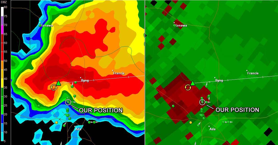 Screen capture of our location form GRLevel 2.
We watched textbook set up of tornado formation right near Ada, Oklahoma. We watched the whole formation of the tornado from start to finish. It was fantastic to watch and we all got the whole thing, start to finish, on video. Here's a screen cap of the tornado I took from my video:
 First tornado of 2011, May 21 near Ada, OK.
In the end we're glad we ended up chasing. It was straight out of Twister (if you've ever seen the movie): Went to a BBQ, sat comfortably and ate well, had a beer, then raced out to go see a tornado! We've also heard reports that there were no injuries which is also good. Unfortunately the internet connection here isn't good enough to upload the photos and videos I've taken from the last two days (May 20 and May 21) so I'll have to do that in the coming couple of days when the internet is better.
Today looks interesting. We're in a 10% hatched area for tornadoes today right where we are. We're going to do some forecasting now to decide where to go.
Third Chase Day - Beautiful Storms
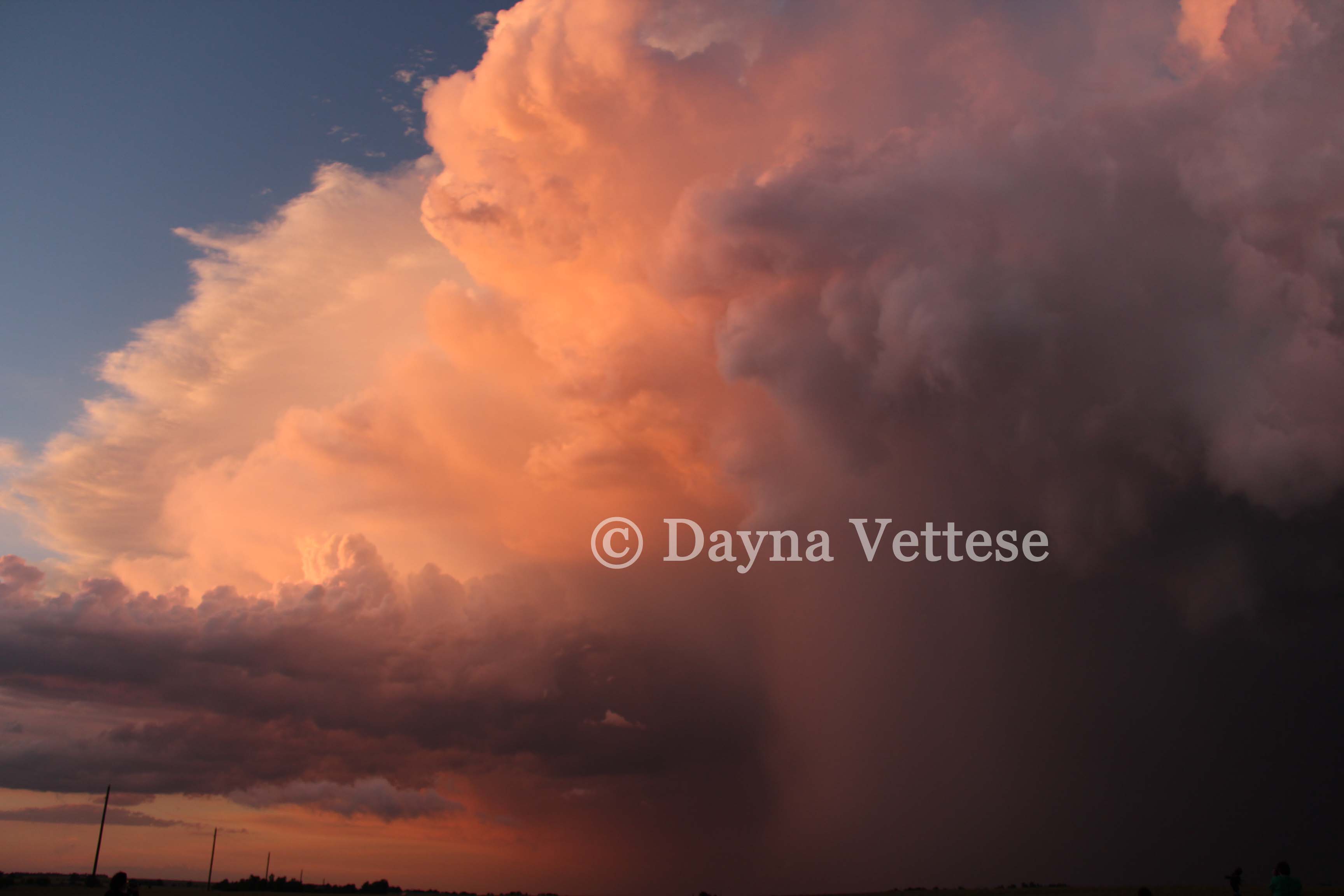
Today did have low potential for tornadoes so the fact that we didn't see one is not surprising. NWS SPC is only reporting one tornado report in far eastern Oklahoma. We began the day in Wichita and travelled to Pratt, Kansas where we had some lunch. Checked the radar after lunch and things were starting to get interesting. The rest of the day consisted of us basically driving in and around Pratt and a dryline sat almost stationary over the town. Storm after storm fired off this boundary. Each of these storms had weak tornadic potential but were visually nice to look at. The last storm of the day required us driving back to Pratt. Once we got just southeast of Pratt, the sun began to set which lead to one of the most beautiful storms I have ever seen. The structure was good but the lighting was spectacular. The colours were vivid oranges, blues, greens, reds, yellows. The photographs and video we got off this last storm is spectacular. Once the sun set we left the storm and drove to Enid, Oklahoma. We're spending the night here (in an awful hotel I might add - if you ever plan on staying in Enid at America's Best or Days Inn - DON'T!!!!!). Also the internet here is terrible so I won't be able to upload anything tonight. However, if you go to my Twitter I attached a Twitpic of the storm. Here's another one of the pictures:
Tomorrow has low potential again so we may or may not chase. There is also the annual chaser BBQ just north of Oklahoma City so we'll most likely head there for the afternoon.
Third Chase Day - Low Potential
Good morning. Just leaving Wichita, KS and heading to Pratt, KS. We spent the night in Wichita and ate at a great restaurant called Texas Roadhouse (yes, Family Guy jokes ensued). Woke up early this morning to an intense thunderstorm. No tornado or hail risk just a lot of rain, lightning, thunder and wind. It is technically our first thunderstorm of the chase and thus makes today not a bust! As fun as that morning convection was to watch, it worked over the atmosphere and will most likely inhibit convection later today. The morning convection stabilized the atmosphere somewhat and we're fairly overcast right now. If we can get enough clearing in the next little while and get some daytime heating, we'll be able to destabilize the atmosphere which will aid in some afternoon/evening convection. The SPC's convective outlook for today is, for lack of a better word, HUGE! It covers most of the continental U.S.
   THE STRONGEST DEEP-LAYER VERTICAL SHEAR /40-50
   KT/ WILL RESIDE ACROSS OK INTO SRN KS...DECREASING TO 30-35 KT IN
   NEB.  AS SUCH...ISOLATED TO WIDELY SCATTERED STORMS /INCLUDING
   SUPERCELLS/ WILL BE POSSIBLE THIS AFTERNOON INTO EVENING WITH THE
   PRIMARY HAZARD BEING LARGE HAIL.
There are storms occurring right now in eastern Oklahoma into Arkansas but it's far too early and the storms look like a mess. We're headed back to western Kansas (most likely Pratt) because, in our opinion, is our best chance for some afternoon/evening convection.
Second Chase Day - Bust
We got spoiled last year... Let's put it that way. Once again the set up was perfect. It was another hot, humid day and all the necessary ingredients were there. Storms started going up but they went up all at once along the dry line. Then then formed into one big mess of thunderstorms. There were several tornado reports in north-central Kansas. We were in more central - south-central Kansas near Pratt. We hung out in Pratt for a while then headed towards storms. Things started to become messy and we had to call it a day. We are all frustrated because the set up was so perfect. We haven't had a chance to really figure out what went wrong today. We'll most likely discuss it over dinner. Last year by this time we had seen several tornadoes but we've been reassured by veteran chasers that this is what chasing is really like! We did get some nice cloud structures which I will post later when we get to the hotel. We'll be spending the night in Wichita, KS and heading south tomorrow towards Oklahoma.
Tomorrow's severe weather outlook is a little ridiculous from a meteorologist's standpoint. The slight risk is massive: extends from southern Texas to southern South Dakota and then in the west from Oklahoma to the east in Arkansas. It's a huge area! We'll narrow down our target tonight.
Going to have dinner now, will update with pictures and videos once we're at the hotel.